Tiszaszőlős geodata
Tiszaszőlős (Jász-Nagykun-Szolnok) is a populated place; located in Hungary in Europe/Budapest (GMT+2) time zone. With population of 1,946 people, there are 809 cities with bigger population in this country. Compared to other cities in Hungary, 59.7% of cities are located further ↓South; 75.1% of cities are located further ←West and 87.7% of cities have higher elevation than Tiszaszőlős. Note1


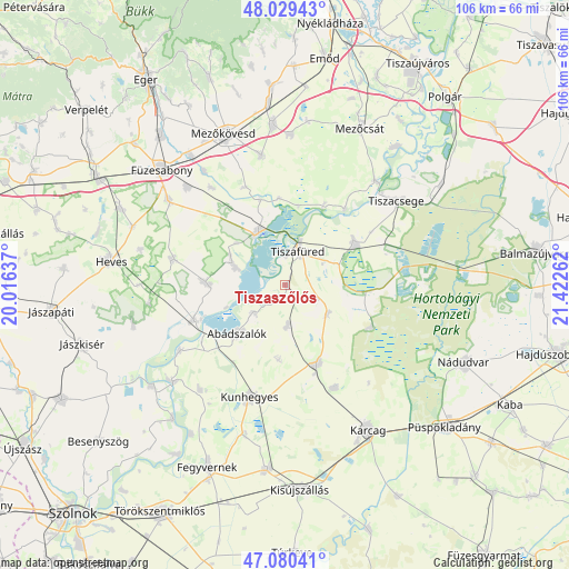
Tiszaszőlős GPS coordinates[2]
47° 33' 25.452" North, 20° 43' 10.164" East
| Map corner | latitude | longitude |
|---|---|---|
| Upper-left | 48.02943°, | 20.01637° |
| Center: | 47.55707°, | 20.71949° |
| Lower-right: | 47.08041°, | 21.42262° |
| Map W x H: | 105.5×105.5 km | = 65.6×65.6mi |
| max Lat: | 48.46667° ⇑40.3% North |
| Tiszaszőlős: | 47.55707° |
| min Lat: | ⇓59.7% South 45.79108° |
| min Long | Tiszaszőlős | max Long |
| 16.27358° | 20.71949° | 22.68096° |
| W 75.1%⇐ | ⇒24.9% E |
Elevation
Elevation of Tiszaszőlős is 88 m = 289 ft, and this is 41.7 m = 137 ft below average elevation for this country.
| Max E: |
444 m = 1457 ft | 87.7% |
| Avg. | 129.7 m = 426 ft | |
| Tiszaszőlős | 88 m = 289 ft | |
Min E: |
71 m = 233 ft | 12.3% |
See also: Hungary elevation on elevation.city.
Geographical zone
Tiszaszőlős is located in North temperate zone (between Tropic of Cancer and the Arctic Circle). Distance of this North polar circle is 2113.3 km =1313.1 mi to North.| Distance of | km | miles | from Tiszaszőlős |
|---|---|---|---|
| North Pole | 4719.2 | 2932.4 | to North |
| Arctic Circle | 2113.3 | 1313.1 | to North |
| Tropic Cancer | 2681.9 | 1666.5 | to South |
| Equator | 5287.9 | 3285.7 | to South |


Nearby cities:
15 places around Tiszaszőlős: (largest is in red/bold)
• Abádszalók
13.5 km =8.4 mi,  221°
221°
• Besenyőtelek
26.7 km =16.6 mi,  306°
306°
• Egyek
16 km =9.9 mi,  57°
57°
• Kisköre
17.7 km =11 mi,  248°
248°
• Kunhegyes
22.1 km =13.7 mi,  197°
197°
• Kunmadaras
15 km =9.3 mi,  156°
156°
• Poroszló
11.1 km =6.9 mi,  339°
339°
• Szentistván
23.6 km =14.7 mi,  350°
350°
• Szihalom
29.3 km =18.2 mi,  322°
322°
• Tiszabura
22.4 km =13.9 mi,  237°
237°
• Tiszacsege
26.4 km =16.4 mi,  52°
52°
• Tiszafüred
7.5 km =4.7 mi,  28°
28°
• Tiszanána
14 km =8.7 mi,  274°
274°
• Tiszaroff
26.7 km =16.6 mi,  229°
229°
• Tiszaszentimre
8.3 km =5.2 mi,  172°
172°
Sources, notices
• [Note1] Compared only with cities in Hungary existing in our database
• [Src1] Map data: © OpenStreetMap contributors (CC-BY-SA)
• [Src2] Other city data from geonames.org with taken over terms of usage.
• [Src3] Geographical zone / Annual Mean Temperature by Robert A. Rohde @ Wikipedia
