Egyek geodata
Egyek (Hajdú-Bihar) is a populated place; located in Hungary in Europe/Budapest (GMT+2) time zone. With population of 5,573 people, there are 273 cities with bigger population in this country. Compared to other cities in Hungary, 65.2% of cities are located further ↓South; 78.5% of cities are located further ←West and 91.3% of cities have higher elevation than Egyek. Note1


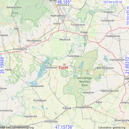
Egyek GPS coordinates[2]
47° 37' 59.988" North, 20° 54' 0" East
| Map corner | latitude | longitude |
|---|---|---|
| Upper-left | 48.105°, | 20.19688° |
| Center: | 47.63333°, | 20.9° |
| Lower-right: | 47.15736°, | 21.60313° |
| Map W x H: | 105.4×105.4 km | = 65.5×65.5mi |
| max Lat: | 48.46667° ⇑34.8% North |
| Egyek: | 47.63333° |
| min Lat: | ⇓65.2% South 45.79108° |
| min Long | Egyek | max Long |
| 16.27358° | 20.9° | 22.68096° |
| W 78.5%⇐ | ⇒21.5% E |
Elevation
Elevation of Egyek is 86 m = 282 ft, and this is 43.7 m = 143 ft below average elevation for this country.
| Max E: |
444 m = 1457 ft | 91.3% |
| Avg. | 129.7 m = 426 ft | |
| Egyek | 86 m = 282 ft | |
Min E: |
71 m = 233 ft | 8.7% |
See also: Hungary elevation on elevation.city.
Geographical zone
Egyek is located in North temperate zone (between Tropic of Cancer and the Arctic Circle). Distance of this North polar circle is 2104.8 km =1307.9 mi to North.| Distance of | km | miles | from Egyek |
|---|---|---|---|
| North Pole | 4710.7 | 2927.1 | to North |
| Arctic Circle | 2104.8 | 1307.9 | to North |
| Tropic Cancer | 2690.4 | 1671.7 | to South |
| Equator | 5296.3 | 3291 | to South |


Nearby cities:
15 places around Egyek: (largest is in red/bold)
• Abádszalók
29.2 km =18.1 mi,  230°
230°
• Csincse
29.9 km =18.6 mi,  340°
340°
• Hejőbába
29.9 km =18.6 mi,  7°
7°
• Hortobágy
19.6 km =12.2 mi,  106°
106°
• Kunmadaras
23.5 km =14.6 mi,  198°
198°
• Mezőcsát
20.4 km =12.7 mi,  3°
3°
• Mezőkeresztes
26.8 km =16.7 mi,  326°
326°
• Poroszló
17.6 km =10.9 mi,  276°
276°
• Szentistván
22.9 km =14.2 mi,  310°
310°
• Tiszacsege
10.5 km =6.5 mi,  45°
45°
• Tiszafüred
10.2 km =6.3 mi,  259°
259°
• Tiszakeszi
18.3 km =11.4 mi,  24°
24°
• Tiszanána
28.5 km =17.7 mi,  254°
254°
• Tiszaszentimre
20.8 km =12.9 mi,  216°
216°
• Tiszaszőlős
16 km =9.9 mi,  237°
237°
Sources, notices
• [Note1] Compared only with cities in Hungary existing in our database
• [Src1] Map data: © OpenStreetMap contributors (CC-BY-SA)
• [Src2] Other city data from geonames.org with taken over terms of usage.
• [Src3] Geographical zone / Annual Mean Temperature by Robert A. Rohde @ Wikipedia
