Vaja geodata
Vaja (Szabolcs-Szatmár-Bereg) is a populated place; located in Hungary in Europe/Budapest (GMT+2) time zone. With population of 3,774 people, there are 394 cities with bigger population in this country. Compared to other cities in Hungary, 87.7% of cities are located further ↓South; 97.2% of cities are located further ←West and 71.9% of cities have lower elevation than Vaja. Note1


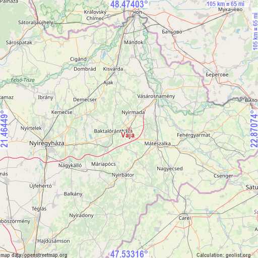
Vaja GPS coordinates[2]
48° 0' 20.664" North, 22° 10' 3.396" East
| Map corner | latitude | longitude |
|---|---|---|
| Upper-left | 48.47403°, | 21.46449° |
| Center: | 48.00574°, | 22.16761° |
| Lower-right: | 47.53316°, | 22.87074° |
| Map W x H: | 104.6×104.6 km | = 65×65mi |
| max Lat: | 48.46667° ⇑12.3% North |
| Vaja: | 48.00574° |
| min Lat: | ⇓87.7% South 45.79108° |
| min Long | Vaja | max Long |
| 16.27358° | 22.16761° | 22.68096° |
| W 97.2%⇐ | ⇒2.8% E |
Elevation
Elevation of Vaja is 140 m = 459 ft, and this is 10.3 m = 34 ft above average elevation for this country.
| Max E: |
444 m = 1457 ft | 28.1% |
| Vaja | 140 m 459 ft | |
| Avg. | 129.7 m = 426 ft | |
Min E: |
71 m = 233 ft | 71.9% |
See also: Hungary elevation on elevation.city.
Geographical zone
Vaja is located in North temperate zone (between Tropic of Cancer and the Arctic Circle). Distance of this North polar circle is 2063.4 km =1282.1 mi to North.| Distance of | km | miles | from Vaja |
|---|---|---|---|
| North Pole | 4669.3 | 2901.4 | to North |
| Arctic Circle | 2063.4 | 1282.1 | to North |
| Tropic Cancer | 2731.8 | 1697.5 | to South |
| Equator | 5337.7 | 3316.7 | to South |


Nearby cities:
15 places around Vaja: (largest is in red/bold)
• Baktalórántháza
6.3 km =3.9 mi,  264°
264°
• Gyulaháza
14.7 km =9.1 mi,  345°
345°
• Hodász
10 km =6.2 mi,  165°
165°
• Kántorjánosi
8.2 km =5.1 mi,  189°
189°
• Levelek
14.4 km =8.9 mi,  250°
250°
• Mátészalka
12.9 km =8 mi,  115°
115°
• Nagydobos
11.7 km =7.3 mi,  60°
60°
• Nyírgyulaj
14.3 km =8.9 mi,  201°
201°
• Nyírkarász
11 km =6.8 mi,  334°
334°
• Nyírmada
7.2 km =4.5 mi,  19°
19°
• Nyírmeggyes
12.3 km =7.6 mi,  143°
143°
• Petneháza
9.2 km =5.7 mi,  311°
311°
• Szamosszeg
15.4 km =9.6 mi,  73°
73°
• Ófehértó
11.9 km =7.4 mi,  227°
227°
• Ópályi
11.8 km =7.3 mi,  94°
94°
Sources, notices
• [Note1] Compared only with cities in Hungary existing in our database
• [Src1] Map data: © OpenStreetMap contributors (CC-BY-SA)
• [Src2] Other city data from geonames.org with taken over terms of usage.
• [Src3] Geographical zone / Annual Mean Temperature by Robert A. Rohde @ Wikipedia
