Tiszakécske geodata
Tiszakécske (Bács-Kiskun) is a seat of a second-order administrative division; located in Hungary in Europe/Budapest (GMT+2) time zone. With population of 11,745 people, there are 142 cities with bigger population in this country. Compared to other cities in Hungary, 71.5% of cities are located further ↑North; 64.3% of cities are located further ←West and 93.3% of cities have higher elevation than Tiszakécske. Note1


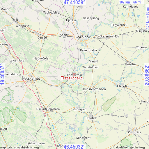
Tiszakécske GPS coordinates[2]
46° 55' 57.396" North, 20° 6' 12.564" East
| Map corner | latitude | longitude |
|---|---|---|
| Upper-left | 47.41059°, | 19.40037° |
| Center: | 46.93261°, | 20.10349° |
| Lower-right: | 46.45032°, | 20.80662° |
| Map W x H: | 106.8×106.8 km | = 66.4×66.4mi |
| max Lat: | 48.46667° ⇑71.5% North |
| Tiszakécske: | 46.93261° |
| min Lat: | ⇓28.5% South 45.79108° |
| min Long | Tiszakécske | max Long |
| 16.27358° | 20.10349° | 22.68096° |
| W 64.3%⇐ | ⇒35.7% E |
Elevation
Elevation of Tiszakécske is 85 m = 279 ft, and this is 44.7 m = 147 ft below average elevation for this country.
| Max E: |
444 m = 1457 ft | 93.3% |
| Avg. | 129.7 m = 426 ft | |
| Tiszakécske | 85 m = 279 ft | |
Min E: |
71 m = 233 ft | 6.7% |
See also: Hungary elevation on elevation.city.
Geographical zone
Tiszakécske is located in North temperate zone (between Tropic of Cancer and the Arctic Circle). Distance of this North polar circle is 2182.8 km =1356.3 mi to North.| Distance of | km | miles | from Tiszakécske |
|---|---|---|---|
| North Pole | 4788.6 | 2975.5 | to North |
| Arctic Circle | 2182.8 | 1356.3 | to North |
| Tropic Cancer | 2612.5 | 1623.3 | to South |
| Equator | 5218.4 | 3242.6 | to South |


Nearby cities:
15 places around Tiszakécske: (largest is in red/bold)
• Cibakháza
7.8 km =4.8 mi,  67°
67°
• Cserkeszőlő
10 km =6.2 mi,  140°
140°
• Jászkarajenő
13.3 km =8.3 mi,  347°
347°
• Kocsér
15.9 km =9.9 mi,  298°
298°
• Kunszentmárton
17.5 km =10.9 mi,  126°
126°
• Lakitelek
10.4 km =6.5 mi,  232°
232°
• Nyárlőrinc
18.9 km =11.7 mi,  244°
244°
• Rákóczifalva
19.4 km =12.1 mi,  30°
30°
• Rákócziújfalu
19.4 km =12.1 mi,  39°
39°
• Szelevény
16.3 km =10.1 mi,  152°
152°
• Szentkirály
14.1 km =8.8 mi,  263°
263°
• Tiszaalpár
15.5 km =9.6 mi,  210°
210°
• Tiszaföldvár
12.5 km =7.8 mi,  63°
63°
• Tószeg
18.9 km =11.7 mi,  10°
10°
• Öcsöd
22.8 km =14.2 mi,  99°
99°
Sources, notices
• [Note1] Compared only with cities in Hungary existing in our database
• [Src1] Map data: © OpenStreetMap contributors (CC-BY-SA)
• [Src2] Other city data from geonames.org with taken over terms of usage.
• [Src3] Geographical zone / Annual Mean Temperature by Robert A. Rohde @ Wikipedia
