Szeged geodata
Szeged (Csongrád) is a seat of a first-order administrative division; located in Hungary in Europe/Budapest (GMT+2) time zone. With population of 164,883 people, there are 3 cities with bigger population in this country. Compared to other cities in Hungary, 94% of cities are located further ↑North; 65% of cities are located further ←West and 94.4% of cities have higher elevation than Szeged. Note1


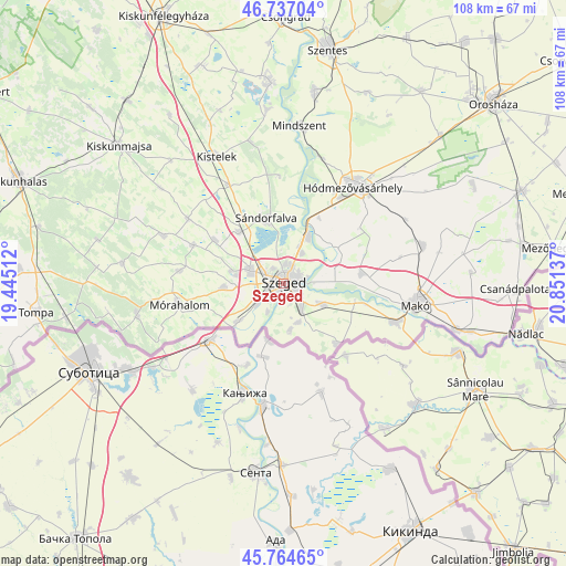
Szeged GPS coordinates[2]
46° 15' 10.8" North, 20° 8' 53.664" East
| Map corner | latitude | longitude |
|---|---|---|
| Upper-left | 46.73704°, | 19.44512° |
| Center: | 46.253°, | 20.14824° |
| Lower-right: | 45.76465°, | 20.85137° |
| Map W x H: | 108.1×108.1 km | = 67.2×67.2mi |
| max Lat: | 48.46667° ⇑94% North |
| Szeged: | 46.253° |
| min Lat: | ⇓6% South 45.79108° |
| min Long | Szeged | max Long |
| 16.27358° | 20.14824° | 22.68096° |
| W 65%⇐ | ⇒35% E |
Elevation
Elevation of Szeged is 84 m = 276 ft, and this is 45.7 m = 150 ft below average elevation for this country.
| Max E: |
444 m = 1457 ft | 94.4% |
| Avg. | 129.7 m = 426 ft | |
| Szeged | 84 m = 276 ft | |
Min E: |
71 m = 233 ft | 5.6% |
See also: Szeged elevation on elevation.city.
Geographical zone
Szeged is located in North temperate zone (between Tropic of Cancer and the Arctic Circle). Distance of this North polar circle is 2258.3 km =1403.2 mi to North.| Distance of | km | miles | from Szeged |
|---|---|---|---|
| North Pole | 4864.2 | 3022.5 | to North |
| Arctic Circle | 2258.3 | 1403.2 | to North |
| Tropic Cancer | 2536.9 | 1576.4 | to South |
| Equator | 5142.9 | 3195.6 | to South |


Nearby cities:
15 places around Szeged: (largest is in red/bold)
• Algyő
10.2 km =6.3 mi,  26°
26°
• Balástya
21.7 km =13.5 mi,  330°
330°
• Bordány
18.8 km =11.7 mi,  292°
292°
• Deszk
8.3 km =5.2 mi,  118°
118°
• Domaszék
10.6 km =6.6 mi,  267°
267°
• Forráskút
22.2 km =13.8 mi,  304°
304°
• Hódmezővásárhely
23.1 km =14.4 mi,  37°
37°
• Kiszombor
23.3 km =14.5 mi,  109°
109°
• Maroslele
15.6 km =9.7 mi,  84°
84°
• Mórahalom
20.6 km =12.8 mi,  259°
259°
• Röszke
11.4 km =7.1 mi,  230°
230°
• Szatymaz
13 km =8.1 mi,  320°
320°
• Sándorfalva
12.6 km =7.8 mi,  342°
342°
• Zsombó
15.6 km =9.7 mi, 301°
• Zákányszék
20 km =12.4 mi,  276°
276°
Sources, notices
• [Note1] Compared only with cities in Hungary existing in our database
• [Src1] Map data: © OpenStreetMap contributors (CC-BY-SA)
• [Src2] Other city data from geonames.org with taken over terms of usage.
• [Src3] Geographical zone / Annual Mean Temperature by Robert A. Rohde @ Wikipedia
