Forráskút geodata
Forráskút (Csongrád) is a populated place; located in Hungary in Europe/Budapest (GMT+2) time zone. With population of 2,287 people, there are 677 cities with bigger population in this country. Compared to other cities in Hungary, 89.9% of cities are located further ↑North; 59.3% of cities are located further ←West and 84.5% of cities have higher elevation than Forráskút. Note1


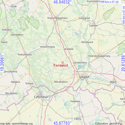
Forráskút GPS coordinates[2]
46° 21' 55.008" North, 19° 54' 35.028" East
| Map corner | latitude | longitude |
|---|---|---|
| Upper-left | 46.84832°, | 19.20661° |
| Center: | 46.36528°, | 19.90973° |
| Lower-right: | 45.87793°, | 20.61286° |
| Map W x H: | 107.9×107.9 km | = 67×67mi |
| max Lat: | 48.46667° ⇑89.9% North |
| Forráskút: | 46.36528° |
| min Lat: | ⇓10.1% South 45.79108° |
| min Long | Forráskút | max Long |
| 16.27358° | 19.90973° | 22.68096° |
| W 59.3%⇐ | ⇒40.7% E |
Elevation
Elevation of Forráskút is 91 m = 299 ft, and this is 38.7 m = 127 ft below average elevation for this country.
| Max E: |
444 m = 1457 ft | 84.5% |
| Avg. | 129.7 m = 426 ft | |
| Forráskút | 91 m = 299 ft | |
Min E: |
71 m = 233 ft | 15.5% |
See also: Hungary elevation on elevation.city.
Geographical zone
Forráskút is located in North temperate zone (between Tropic of Cancer and the Arctic Circle). Distance of this North polar circle is 2245.8 km =1395.5 mi to North.| Distance of | km | miles | from Forráskút |
|---|---|---|---|
| North Pole | 4851.7 | 3014.7 | to North |
| Arctic Circle | 2245.8 | 1395.5 | to North |
| Tropic Cancer | 2549.4 | 1584.1 | to South |
| Equator | 5155.3 | 3203.4 | to South |


Nearby cities:
15 places around Forráskút: (largest is in red/bold)
• Balástya
9.9 km =6.2 mi,  49°
49°
• Bordány
5.3 km =3.3 mi,  168°
168°
• Csengele
20 km =12.4 mi,  349°
349°
• Domaszék
15.1 km =9.4 mi,  148°
148°
• Kiskunmajsa
19 km =11.8 mi,  316°
316°
• Kistelek
13.1 km =8.1 mi,  24°
24°
• Mórahalom
16.5 km =10.3 mi,  186°
186°
• Ruzsa
15.2 km =9.4 mi,  235°
235°
• Szatymaz
10.3 km =6.4 mi,  103°
103°
• Sándorfalva
14.5 km =9 mi,  91°
91°
• Zsombó
6.7 km =4.2 mi,  131°
131°
• Zákányszék
10.2 km =6.3 mi, 188°
• Ásotthalom
20.9 km =13 mi,  207°
207°
• Ópusztaszer
19.1 km =11.9 mi, 45°
• Üllés
6 km =3.7 mi, 237°
Sources, notices
• [Note1] Compared only with cities in Hungary existing in our database
• [Src1] Map data: © OpenStreetMap contributors (CC-BY-SA)
• [Src2] Other city data from geonames.org with taken over terms of usage.
• [Src3] Geographical zone / Annual Mean Temperature by Robert A. Rohde @ Wikipedia
