Algyő geodata
Algyő (Csongrád) is a populated place; located in Hungary in Europe/Budapest (GMT+2) time zone. With population of 5,247 people, there are 286 cities with bigger population in this country. Compared to other cities in Hungary, 91.3% of cities are located further ↑North; 66.3% of cities are located further ←West and 99.6% of cities have higher elevation than Algyő. Note1


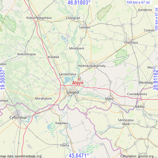
Algyő GPS coordinates[2]
46° 20' 4.992" North, 20° 12' 30.564" East
| Map corner | latitude | longitude |
|---|---|---|
| Upper-left | 46.81803°, | 19.50537° |
| Center: | 46.33472°, | 20.20849° |
| Lower-right: | 45.8471°, | 20.91162° |
| Map W x H: | 108×108 km | = 67.1×67.1mi |
| max Lat: | 48.46667° ⇑91.3% North |
| Algyő: | 46.33472° |
| min Lat: | ⇓8.7% South 45.79108° |
| min Long | Algyő | max Long |
| 16.27358° | 20.20849° | 22.68096° |
| W 66.3%⇐ | ⇒33.7% E |
Elevation
Elevation of Algyő is 78 m = 256 ft, and this is 51.7 m = 170 ft below average elevation for this country.
| Max E: |
444 m = 1457 ft | 99.6% |
| Avg. | 129.7 m = 426 ft | |
| Algyő | 78 m = 256 ft | |
Min E: |
71 m = 233 ft | 0.4% |
See also: Hungary elevation on elevation.city.
Geographical zone
Algyő is located in North temperate zone (between Tropic of Cancer and the Arctic Circle). Distance of this North polar circle is 2249.2 km =1397.6 mi to North.| Distance of | km | miles | from Algyő |
|---|---|---|---|
| North Pole | 4855.1 | 3016.8 | to North |
| Arctic Circle | 2249.2 | 1397.6 | to North |
| Tropic Cancer | 2546 | 1582 | to South |
| Equator | 5151.9 | 3201.2 | to South |


Nearby cities:
15 places around Algyő: (largest is in red/bold)
• Balástya
18.2 km =11.3 mi,  302°
302°
• Bordány
22 km =13.7 mi,  265°
265°
• Deszk
13.2 km =8.2 mi,  168°
168°
• Domaszék
17.9 km =11.1 mi,  237°
237°
• Forráskút
23.2 km =14.4 mi,  278°
278°
• Földeák
22.5 km =14 mi,  95°
95°
• Hódmezővásárhely
13.2 km =8.2 mi,  46°
46°
• Maroslele
13.2 km =8.2 mi,  124°
124°
• Mindszent
21 km =13 mi,  356°
356°
• Röszke
21.1 km =13.1 mi,  219°
219°
• Szatymaz
13 km =8.1 mi, 274°
• Szeged
10.2 km =6.3 mi,  206°
206°
• Sándorfalva
8.9 km =5.5 mi,  289°
289°
• Zsombó
18 km =11.2 mi, 266°
• Ópusztaszer
19.2 km =11.9 mi,  331°
331°
Sources, notices
• [Note1] Compared only with cities in Hungary existing in our database
• [Src1] Map data: © OpenStreetMap contributors (CC-BY-SA)
• [Src2] Other city data from geonames.org with taken over terms of usage.
• [Src3] Geographical zone / Annual Mean Temperature by Robert A. Rohde @ Wikipedia
