Szarvas geodata
Szarvas (Bekes) is a seat of a second-order administrative division; located in Hungary in Europe/Budapest (GMT+2) time zone. With population of 18,170 people, there are 94 cities with bigger population in this country. Compared to other cities in Hungary, 74% of cities are located further ↑North; 72.5% of cities are located further ←West and 97.3% of cities have higher elevation than Szarvas. Note1


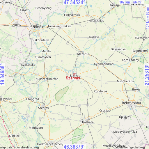
Szarvas GPS coordinates[2]
46° 52' 0.012" North, 20° 33' 0" East
| Map corner | latitude | longitude |
|---|---|---|
| Upper-left | 47.34524°, | 19.84688° |
| Center: | 46.86667°, | 20.55° |
| Lower-right: | 46.38379°, | 21.25313° |
| Map W x H: | 106.9×106.9 km | = 66.4×66.4mi |
| max Lat: | 48.46667° ⇑74% North |
| Szarvas: | 46.86667° |
| min Lat: | ⇓26% South 45.79108° |
| min Long | Szarvas | max Long |
| 16.27358° | 20.55° | 22.68096° |
| W 72.5%⇐ | ⇒27.5% E |
Elevation
Elevation of Szarvas is 82 m = 269 ft, and this is 47.7 m = 156 ft below average elevation for this country.
| Max E: |
444 m = 1457 ft | 97.3% |
| Avg. | 129.7 m = 426 ft | |
| Szarvas | 82 m = 269 ft | |
Min E: |
71 m = 233 ft | 2.7% |
See also: Hungary elevation on elevation.city.
Geographical zone
Szarvas is located in North temperate zone (between Tropic of Cancer and the Arctic Circle). Distance of this North polar circle is 2190.1 km =1360.9 mi to North.| Distance of | km | miles | from Szarvas |
|---|---|---|---|
| North Pole | 4796 | 2980.1 | to North |
| Arctic Circle | 2190.1 | 1360.9 | to North |
| Tropic Cancer | 2605.2 | 1618.8 | to South |
| Equator | 5211.1 | 3238 | to South |


Nearby cities:
15 places around Szarvas: (largest is in red/bold)
• Békésszentandrás
5.1 km =3.2 mi,  270°
270°
• Cibakháza
28.7 km =17.8 mi,  291°
291°
• Cserkeszőlő
27.6 km =17.1 mi, 269°
• Fábiánsebestyén
21.4 km =13.3 mi,  197°
197°
• Gyomaendrőd
22.8 km =14.2 mi,  70°
70°
• Gádoros
22.6 km =14 mi,  170°
170°
• Kardos
14.9 km =9.3 mi,  120°
120°
• Kengyel
29.2 km =18.1 mi,  325°
325°
• Kondoros
22 km =13.7 mi, 120°
• Kunszentmárton
20.1 km =12.5 mi,  261°
261°
• Mezőtúr
16.1 km =10 mi,  23°
23°
• Nagyszénás
22.2 km =13.8 mi,  156°
156°
• Szelevény
27.4 km =17 mi,  254°
254°
• Tiszaföldvár
26.2 km =16.3 mi,  299°
299°
• Öcsöd
12 km =7.5 mi, 288°
Sources, notices
• [Note1] Compared only with cities in Hungary existing in our database
• [Src1] Map data: © OpenStreetMap contributors (CC-BY-SA)
• [Src2] Other city data from geonames.org with taken over terms of usage.
• [Src3] Geographical zone / Annual Mean Temperature by Robert A. Rohde @ Wikipedia
