Nagyszénás geodata
Nagyszénás (Bekes) is a populated place; located in Hungary in Europe/Budapest (GMT+2) time zone. With population of 5,617 people, there are 269 cities with bigger population in this country. Compared to other cities in Hungary, 81.2% of cities are located further ↑North; 73.8% of cities are located further ←West and 96.4% of cities have higher elevation than Nagyszénás. Note1


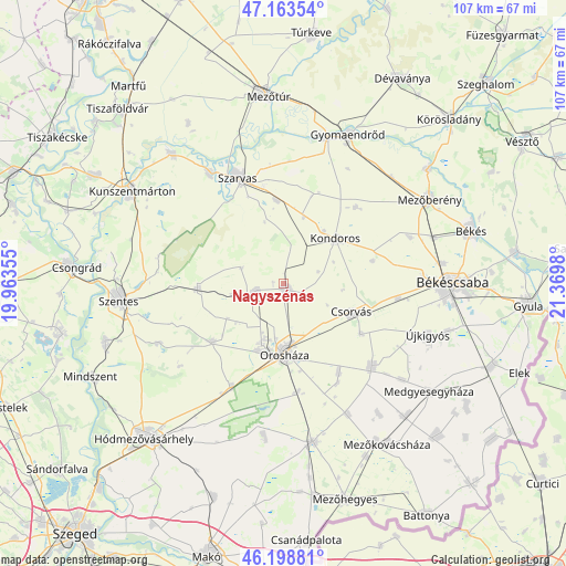
Nagyszénás GPS coordinates[2]
46° 40' 59.988" North, 20° 40' 0.012" East
| Map corner | latitude | longitude |
|---|---|---|
| Upper-left | 47.16354°, | 19.96355° |
| Center: | 46.68333°, | 20.66667° |
| Lower-right: | 46.19881°, | 21.3698° |
| Map W x H: | 107.3×107.3 km | = 66.7×66.7mi |
| max Lat: | 48.46667° ⇑81.2% North |
| Nagyszénás: | 46.68333° |
| min Lat: | ⇓18.8% South 45.79108° |
| min Long | Nagyszénás | max Long |
| 16.27358° | 20.66667° | 22.68096° |
| W 73.8%⇐ | ⇒26.2% E |
Elevation
Elevation of Nagyszénás is 83 m = 272 ft, and this is 46.7 m = 153 ft below average elevation for this country.
| Max E: |
444 m = 1457 ft | 96.4% |
| Avg. | 129.7 m = 426 ft | |
| Nagyszénás | 83 m = 272 ft | |
Min E: |
71 m = 233 ft | 3.6% |
See also: Hungary elevation on elevation.city.
Geographical zone
Nagyszénás is located in North temperate zone (between Tropic of Cancer and the Arctic Circle). Distance of this North polar circle is 2210.5 km =1373.5 mi to North.| Distance of | km | miles | from Nagyszénás |
|---|---|---|---|
| North Pole | 4816.4 | 2992.8 | to North |
| Arctic Circle | 2210.5 | 1373.5 | to North |
| Tropic Cancer | 2584.8 | 1606.1 | to South |
| Equator | 5190.7 | 3225.4 | to South |


Nearby cities:
15 places around Nagyszénás: (largest is in red/bold)
• Békésszentandrás
24.7 km =15.3 mi,  325°
325°
• Békéssámson
29.8 km =18.5 mi,  184°
184°
• Csanádapáca
22.2 km =13.8 mi,  131°
131°
• Csorvás
13.9 km =8.6 mi,  113°
113°
• Fábiánsebestyén
15.3 km =9.5 mi,  270°
270°
• Gádoros
5.4 km =3.4 mi,  249°
249°
• Kardos
13.3 km =8.3 mi,  17°
17°
• Kaszaper
27.3 km =17 mi,  152°
152°
• Kondoros
13.8 km =8.6 mi,  47°
47°
• Orosháza
13 km =8.1 mi, 180°
• Pusztaföldvár
19.5 km =12.1 mi, 148°
• Szarvas
22.2 km =13.8 mi,  336°
336°
• Székkutas
22.8 km =14.2 mi,  206°
206°
• Tótkomlós
30.1 km =18.7 mi,  170°
170°
• Újkígyós
30.1 km =18.7 mi, 111°
Sources, notices
• [Note1] Compared only with cities in Hungary existing in our database
• [Src1] Map data: © OpenStreetMap contributors (CC-BY-SA)
• [Src2] Other city data from geonames.org with taken over terms of usage.
• [Src3] Geographical zone / Annual Mean Temperature by Robert A. Rohde @ Wikipedia
