Sirok geodata
Sirok (Heves) is a populated place; located in Hungary in Europe/Budapest (GMT+2) time zone. With population of 2,068 people, there are 751 cities with bigger population in this country. Compared to other cities in Hungary, 83.9% of cities are located further ↓South; 66% of cities are located further ←West and 85% of cities have lower elevation than Sirok. Note1


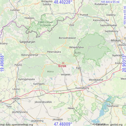
Sirok GPS coordinates[2]
47° 55' 59.988" North, 20° 12' 0" East
| Map corner | latitude | longitude |
|---|---|---|
| Upper-left | 48.40228°, | 19.49688° |
| Center: | 47.93333°, | 20.2° |
| Lower-right: | 47.46009°, | 20.90313° |
| Map W x H: | 104.8×104.8 km | = 65.1×65.1mi |
| max Lat: | 48.46667° ⇑16.1% North |
| Sirok: | 47.93333° |
| min Lat: | ⇓83.9% South 45.79108° |
| min Long | Sirok | max Long |
| 16.27358° | 20.2° | 22.68096° |
| W 66%⇐ | ⇒34% E |
Elevation
Elevation of Sirok is 173 m = 568 ft, and this is 43.3 m = 142 ft above average elevation for this country.
| Max E: |
444 m = 1457 ft | 15% |
| Sirok | 173 m 568 ft | |
| Avg. | 129.7 m = 426 ft | |
Min E: |
71 m = 233 ft | 85% |
See also: Hungary elevation on elevation.city.
Geographical zone
Sirok is located in North temperate zone (between Tropic of Cancer and the Arctic Circle). Distance of this North polar circle is 2071.5 km =1287.2 mi to North.| Distance of | km | miles | from Sirok |
|---|---|---|---|
| North Pole | 4677.4 | 2906.4 | to North |
| Arctic Circle | 2071.5 | 1287.2 | to North |
| Tropic Cancer | 2723.8 | 1692.5 | to South |
| Equator | 5329.7 | 3311.7 | to South |


Nearby cities:
15 places around Sirok: (largest is in red/bold)
• Andornaktálya
18.6 km =11.6 mi,  119°
119°
• Bélapátfalva
17.9 km =11.1 mi,  43°
43°
• Domoszló
12.7 km =7.9 mi,  209°
209°
• Eger
13.4 km =8.3 mi,  104°
104°
• Egerszalók
12.4 km =7.7 mi,  126°
126°
• Felsőtárkány
16.6 km =10.3 mi,  77°
77°
• Kerecsend
18.6 km =11.6 mi,  142°
142°
• Mátraderecske
8.9 km =5.5 mi,  282°
282°
• Ostoros
18.9 km =11.7 mi,  113°
113°
• Parád
12.7 km =7.9 mi,  264°
264°
• Parádsasvár
16.8 km =10.4 mi, 262°
• Pétervására
11.9 km =7.4 mi,  321°
321°
• Recsk
6.2 km =3.9 mi,  270°
270°
• Tarnalelesz
13 km =8.1 mi,  354°
354°
• Verpelét
9.6 km =6 mi,  164°
164°
Sources, notices
• [Note1] Compared only with cities in Hungary existing in our database
• [Src1] Map data: © OpenStreetMap contributors (CC-BY-SA)
• [Src2] Other city data from geonames.org with taken over terms of usage.
• [Src3] Geographical zone / Annual Mean Temperature by Robert A. Rohde @ Wikipedia
