Parád geodata
Parád (Heves) is a populated place; located in Hungary in Europe/Budapest (GMT+2) time zone. With population of 2,111 people, there are 737 cities with bigger population in this country. Compared to other cities in Hungary, 83.4% of cities are located further ↓South; 62.5% of cities are located further ←West and 96.2% of cities have lower elevation than Parád. Note1


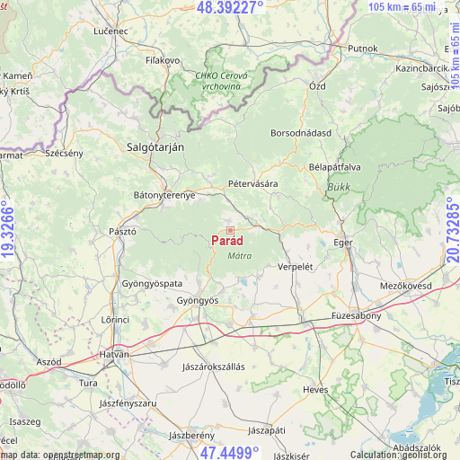
Parád GPS coordinates[2]
47° 55' 23.628" North, 20° 1' 46.992" East
| Map corner | latitude | longitude |
|---|---|---|
| Upper-left | 48.39227°, | 19.3266° |
| Center: | 47.92323°, | 20.02972° |
| Lower-right: | 47.4499°, | 20.73285° |
| Map W x H: | 104.8×104.8 km | = 65.1×65.1mi |
| max Lat: | 48.46667° ⇑16.6% North |
| Parád: | 47.92323° |
| min Lat: | ⇓83.4% South 45.79108° |
| min Long | Parád | max Long |
| 16.27358° | 20.02972° | 22.68096° |
| W 62.5%⇐ | ⇒37.5% E |
Elevation
Elevation of Parád is 236 m = 774 ft, and this is 106.3 m = 349 ft above average elevation for this country.
| Max E: |
444 m = 1457 ft | 3.8% |
| Parád | 236 m 774 ft | |
| Avg. | 129.7 m = 426 ft | |
Min E: |
71 m = 233 ft | 96.2% |
See also: Hungary elevation on elevation.city.
Geographical zone
Parád is located in North temperate zone (between Tropic of Cancer and the Arctic Circle). Distance of this North polar circle is 2072.6 km =1287.9 mi to North.| Distance of | km | miles | from Parád |
|---|---|---|---|
| North Pole | 4678.5 | 2907.1 | to North |
| Arctic Circle | 2072.6 | 1287.9 | to North |
| Tropic Cancer | 2722.6 | 1691.7 | to South |
| Equator | 5328.6 | 3311 | to South |


Nearby cities:
15 places around Parád: (largest is in red/bold)
• Abasár
14.2 km =8.8 mi,  188°
188°
• Bátonyterenye
15 km =9.3 mi,  290°
290°
• Domoszló
11.9 km =7.4 mi,  147°
147°
• Gyöngyös
17.4 km =10.8 mi,  205°
205°
• Gyöngyössolymos
13.7 km =8.5 mi, 210°
• Gyöngyöstarján
17.2 km =10.7 mi,  224°
224°
• Mátraderecske
5 km =3.1 mi,  53°
53°
• Mátranovák
13.2 km =8.2 mi,  344°
344°
• Mátraterenye
13.6 km =8.5 mi,  333°
333°
• Parádsasvár
4.1 km =2.5 mi,  253°
253°
• Pétervására
11.6 km =7.2 mi,  26°
26°
• Recsk
6.6 km =4.1 mi,  80°
80°
• Sirok
12.7 km =7.9 mi, 84°
• Tarnalelesz
18.1 km =11.2 mi,  39°
39°
• Verpelét
17.2 km =10.7 mi,  118°
118°
Sources, notices
• [Note1] Compared only with cities in Hungary existing in our database
• [Src1] Map data: © OpenStreetMap contributors (CC-BY-SA)
• [Src2] Other city data from geonames.org with taken over terms of usage.
• [Src3] Geographical zone / Annual Mean Temperature by Robert A. Rohde @ Wikipedia
