Mátraderecske geodata
Mátraderecske (Heves) is a populated place; located in Hungary in Europe/Budapest (GMT+2) time zone. With population of 2,232 people, there are 698 cities with bigger population in this country. Compared to other cities in Hungary, 84.9% of cities are located further ↓South; 63.5% of cities are located further ←West and 94.1% of cities have lower elevation than Mátraderecske. Note1


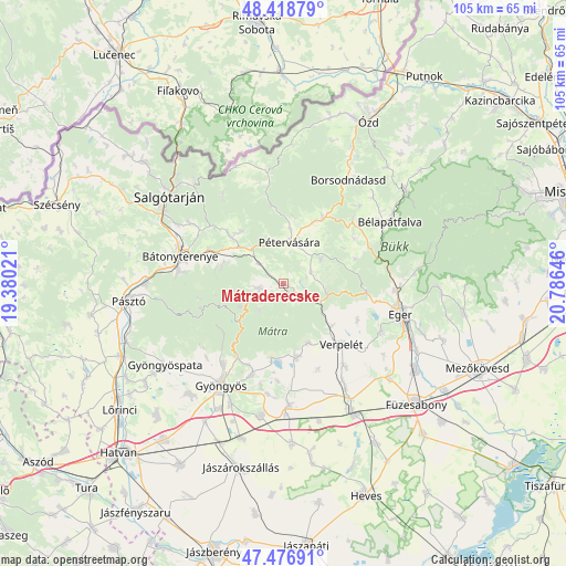
Mátraderecske GPS coordinates[2]
47° 57' 0" North, 20° 4' 59.988" East
| Map corner | latitude | longitude |
|---|---|---|
| Upper-left | 48.41879°, | 19.38021° |
| Center: | 47.95°, | 20.08333° |
| Lower-right: | 47.47691°, | 20.78646° |
| Map W x H: | 104.7×104.7 km | = 65.1×65.1mi |
| max Lat: | 48.46667° ⇑15.1% North |
| Mátraderecske: | 47.95° |
| min Lat: | ⇓84.9% South 45.79108° |
| min Long | Mátraderecske | max Long |
| 16.27358° | 20.08333° | 22.68096° |
| W 63.5%⇐ | ⇒36.5% E |
Elevation
Elevation of Mátraderecske is 214 m = 702 ft, and this is 84.3 m = 277 ft above average elevation for this country.
| Max E: |
444 m = 1457 ft | 5.9% |
| Mátraderecske | 214 m 702 ft | |
| Avg. | 129.7 m = 426 ft | |
Min E: |
71 m = 233 ft | 94.1% |
See also: Hungary elevation on elevation.city.
Geographical zone
Mátraderecske is located in North temperate zone (between Tropic of Cancer and the Arctic Circle). Distance of this North polar circle is 2069.6 km =1286 mi to North.| Distance of | km | miles | from Mátraderecske |
|---|---|---|---|
| North Pole | 4675.5 | 2905.2 | to North |
| Arctic Circle | 2069.6 | 1286 | to North |
| Tropic Cancer | 2725.6 | 1693.6 | to South |
| Equator | 5331.5 | 3312.8 | to South |


Nearby cities:
15 places around Mátraderecske: (largest is in red/bold)
• Abasár
18 km =11.2 mi,  199°
199°
• Bátonyterenye
18.2 km =11.3 mi,  276°
276°
• Domoszló
13.2 km =8.2 mi,  169°
169°
• Egerszalók
20.8 km =12.9 mi,  116°
116°
• Gyöngyössolymos
18.4 km =11.4 mi,  216°
216°
• Kazár
19.9 km =12.4 mi,  303°
303°
• Mátranovák
12.3 km =7.6 mi,  322°
322°
• Mátraterenye
13.7 km =8.5 mi,  312°
312°
• Parád
5 km =3.1 mi,  233°
233°
• Parádsasvár
8.9 km =5.5 mi,  242°
242°
• Pétervására
7.5 km =4.7 mi,  9°
9°
• Recsk
3.1 km =1.9 mi,  126°
126°
• Sirok
8.9 km =5.5 mi,  102°
102°
• Tarnalelesz
13.4 km =8.3 mi,  33°
33°
• Verpelét
15.8 km =9.8 mi, 134°
Sources, notices
• [Note1] Compared only with cities in Hungary existing in our database
• [Src1] Map data: © OpenStreetMap contributors (CC-BY-SA)
• [Src2] Other city data from geonames.org with taken over terms of usage.
• [Src3] Geographical zone / Annual Mean Temperature by Robert A. Rohde @ Wikipedia
