Parádsasvár geodata
Parádsasvár (Heves) is a populated place; located in Hungary in Europe/Budapest (GMT+2) time zone. With population of 76,000 people, there are 23 cities with bigger population in this country. Compared to other cities in Hungary, 82.9% of cities are located further ↓South; 61.1% of cities are located further ←West and 99.6% of cities have lower elevation than Parádsasvár. Note1


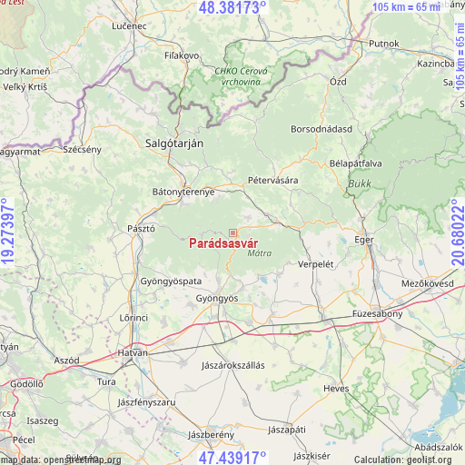
Parádsasvár GPS coordinates[2]
47° 54' 45.36" North, 19° 58' 37.524" East
| Map corner | latitude | longitude |
|---|---|---|
| Upper-left | 48.38173°, | 19.27397° |
| Center: | 47.9126°, | 19.97709° |
| Lower-right: | 47.43917°, | 20.68022° |
| Map W x H: | 104.8×104.8 km | = 65.1×65.1mi |
| max Lat: | 48.46667° ⇑17.1% North |
| Parádsasvár: | 47.9126° |
| min Lat: | ⇓82.9% South 45.79108° |
| min Long | Parádsasvár | max Long |
| 16.27358° | 19.97709° | 22.68096° |
| W 61.1%⇐ | ⇒38.9% E |
Elevation
Elevation of Parádsasvár is 357 m = 1171 ft, and this is 227.3 m = 746 ft above average elevation for this country.
| Max E: |
444 m = 1457 ft | 0.40000000000001% |
| Parádsasvár | 357 m 1171 ft | |
| Avg. | 129.7 m = 426 ft | |
Min E: |
71 m = 233 ft | 99.6% |
See also: Parádsasvár elevation on elevation.city.
Geographical zone
Parádsasvár is located in North temperate zone (between Tropic of Cancer and the Arctic Circle). Distance of this North polar circle is 2073.8 km =1288.6 mi to North.| Distance of | km | miles | from Parádsasvár |
|---|---|---|---|
| North Pole | 4679.7 | 2907.8 | to North |
| Arctic Circle | 2073.8 | 1288.6 | to North |
| Tropic Cancer | 2721.5 | 1691.1 | to South |
| Equator | 5327.4 | 3310.3 | to South |


Nearby cities:
15 places around Parádsasvár: (largest is in red/bold)
• Abasár
13 km =8.1 mi,  171°
171°
• Bátonyterenye
12 km =7.5 mi,  301°
301°
• Domoszló
13.6 km =8.5 mi,  130°
130°
• Gyöngyös
14.9 km =9.3 mi,  194°
194°
• Gyöngyössolymos
11 km =6.8 mi,  196°
196°
• Gyöngyöstarján
13.7 km =8.5 mi,  216°
216°
• Kazár
17.5 km =10.9 mi,  330°
330°
• Mátraderecske
8.9 km =5.5 mi,  62°
62°
• Mátranovák
14 km =8.7 mi,  1°
1°
• Mátraterenye
13.5 km =8.4 mi,  350°
350°
• Mátraverebély
16.2 km =10.1 mi, 295°
• Parád
4.1 km =2.5 mi,  73°
73°
• Pétervására
14.8 km =9.2 mi,  38°
38°
• Recsk
10.7 km =6.6 mi,  77°
77°
• Sirok
16.8 km =10.4 mi, 82°
Sources, notices
• [Note1] Compared only with cities in Hungary existing in our database
• [Src1] Map data: © OpenStreetMap contributors (CC-BY-SA)
• [Src2] Other city data from geonames.org with taken over terms of usage.
• [Src3] Geographical zone / Annual Mean Temperature by Robert A. Rohde @ Wikipedia
