Ricse geodata
Ricse (Borsod-Abaúj-Zemplén) is a populated place; located in Hungary in Europe/Budapest (GMT+2) time zone. With population of 1,907 people, there are 822 cities with bigger population in this country. Compared to other cities in Hungary, 99.1% of cities are located further ↓South; 94.1% of cities are located further ←West and 69.7% of cities have higher elevation than Ricse. Note1


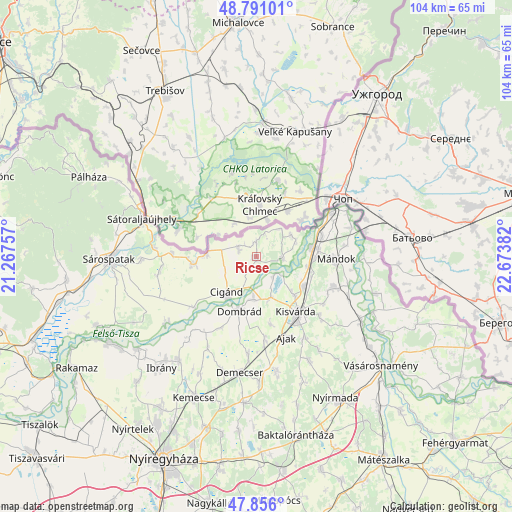
Ricse GPS coordinates[2]
48° 19' 32.34" North, 21° 58' 14.484" East
| Map corner | latitude | longitude |
|---|---|---|
| Upper-left | 48.79101°, | 21.26757° |
| Center: | 48.32565°, | 21.97069° |
| Lower-right: | 47.856°, | 22.67382° |
| Map W x H: | 104×104 km | = 64.6×64.6mi |
| max Lat: | 48.46667° ⇑0.9% North |
| Ricse: | 48.32565° |
| min Lat: | ⇓99.1% South 45.79108° |
| min Long | Ricse | max Long |
| 16.27358° | 21.97069° | 22.68096° |
| W 94.1%⇐ | ⇒5.9% E |
Elevation
Elevation of Ricse is 102 m = 335 ft, and this is 27.7 m = 91 ft below average elevation for this country.
| Max E: |
444 m = 1457 ft | 69.7% |
| Avg. | 129.7 m = 426 ft | |
| Ricse | 102 m = 335 ft | |
Min E: |
71 m = 233 ft | 30.3% |
See also: Hungary elevation on elevation.city.
Geographical zone
Ricse is located in North temperate zone (between Tropic of Cancer and the Arctic Circle). Distance of this North polar circle is 2027.9 km =1260.1 mi to North.| Distance of | km | miles | from Ricse |
|---|---|---|---|
| North Pole | 4633.8 | 2879.3 | to North |
| Arctic Circle | 2027.9 | 1260.1 | to North |
| Tropic Cancer | 2767.4 | 1719.6 | to South |
| Equator | 5373.3 | 3338.8 | to South |


Nearby cities:
15 places around Ricse: (largest is in red/bold)
• Ajak
17.9 km =11.1 mi,  157°
157°
• Anarcs
19.6 km =12.2 mi,  147°
147°
• Cigánd
9.7 km =6 mi,  216°
216°
• Dombrád
10.6 km =6.6 mi,  195°
195°
• Döge
9.8 km =6.1 mi,  135°
135°
• Fényeslitke
11.3 km =7 mi,  122°
122°
• Karcsa
12.3 km =7.6 mi,  262°
262°
• Kisvárda
14.7 km =9.1 mi, 145°
• Mándok
16.3 km =10.1 mi,  91°
91°
• Pátroha
17.8 km =11.1 mi,  173°
173°
• Tiszabezdéd
14 km =8.7 mi,  71°
71°
• Tornyospálca
17 km =10.6 mi,  112°
112°
• Tuzsér
11.1 km =6.9 mi,  79°
79°
• Záhony
17.8 km =11.1 mi,  58°
58°
• Újdombrád
16.3 km =10.1 mi,  207°
207°
Sources, notices
• [Note1] Compared only with cities in Hungary existing in our database
• [Src1] Map data: © OpenStreetMap contributors (CC-BY-SA)
• [Src2] Other city data from geonames.org with taken over terms of usage.
• [Src3] Geographical zone / Annual Mean Temperature by Robert A. Rohde @ Wikipedia
