Nyíregyháza geodata
Nyíregyháza (Szabolcs-Szatmár-Bereg) is a seat of a first-order administrative division; located in Hungary in Europe/Budapest (GMT+2) time zone. With population of 116,298 people, there are 9 cities with bigger population in this country. Compared to other cities in Hungary, 85.6% of cities are located further ↓South; 90.9% of cities are located further ←West and 58.1% of cities have higher elevation than Nyíregyháza. Note1


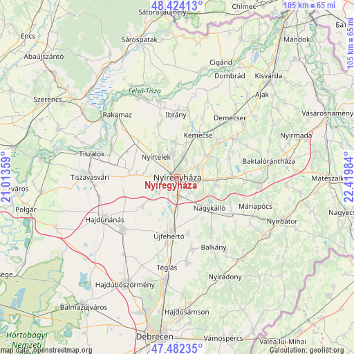
Nyíregyháza GPS coordinates[2]
47° 57' 19.404" North, 21° 43' 0.156" East
| Map corner | latitude | longitude |
|---|---|---|
| Upper-left | 48.42413°, | 21.01359° |
| Center: | 47.95539°, | 21.71671° |
| Lower-right: | 47.48235°, | 22.41984° |
| Map W x H: | 104.7×104.7 km | = 65.1×65.1mi |
| max Lat: | 48.46667° ⇑14.4% North |
| Nyíregyháza: | 47.95539° |
| min Lat: | ⇓85.6% South 45.79108° |
| min Long | Nyíregyháza | max Long |
| 16.27358° | 21.71671° | 22.68096° |
| W 90.9%⇐ | ⇒9.1% E |
Elevation
Elevation of Nyíregyháza is 111 m = 364 ft, and this is 18.7 m = 61 ft below average elevation for this country.
| Max E: |
444 m = 1457 ft | 58.1% |
| Avg. | 129.7 m = 426 ft | |
| Nyíregyháza | 111 m = 364 ft | |
Min E: |
71 m = 233 ft | 41.9% |
See also: Nyíregyháza elevation on elevation.city.
Geographical zone
Nyíregyháza is located in North temperate zone (between Tropic of Cancer and the Arctic Circle). Distance of this North polar circle is 2069 km =1285.6 mi to North.| Distance of | km | miles | from Nyíregyháza |
|---|---|---|---|
| North Pole | 4674.9 | 2904.8 | to North |
| Arctic Circle | 2069 | 1285.6 | to North |
| Tropic Cancer | 2726.2 | 1694 | to South |
| Equator | 5332.1 | 3313.2 | to South |


Nearby cities:
15 places around Nyíregyháza: (largest is in red/bold)
• Apagy
16.3 km =10.1 mi,  86°
86°
• Buj
16.8 km =10.4 mi,  342°
342°
• Ibrány
18.7 km =11.6 mi,  358°
358°
• Kemecse
14.9 km =9.3 mi,  26°
26°
• Kállósemjén
19.6 km =12.2 mi,  122°
122°
• Kálmánháza
12.8 km =8 mi,  231°
231°
• Kótaj
10.5 km =6.5 mi, 359°
• Nagycserkesz
13.7 km =8.5 mi,  275°
275°
• Nagyhalász
20 km =12.4 mi,  9°
9°
• Nagykálló
12.9 km =8 mi,  134°
134°
• Napkor
11.4 km =7.1 mi,  99°
99°
• Nyírbogdány
16.7 km =10.4 mi,  47°
47°
• Nyírpazony
6.9 km =4.3 mi,  63°
63°
• Nyírtelek
9.2 km =5.7 mi,  317°
317°
• Újfehértó
17.5 km =10.9 mi,  188°
188°
Sources, notices
• [Note1] Compared only with cities in Hungary existing in our database
• [Src1] Map data: © OpenStreetMap contributors (CC-BY-SA)
• [Src2] Other city data from geonames.org with taken over terms of usage.
• [Src3] Geographical zone / Annual Mean Temperature by Robert A. Rohde @ Wikipedia
