Újfehértó geodata
Újfehértó (Szabolcs-Szatmár-Bereg) is a populated place; located in Hungary in Europe/Budapest (GMT+2) time zone. With population of 13,542 people, there are 120 cities with bigger population in this country. Compared to other cities in Hungary, 77.5% of cities are located further ↓South; 90.3% of cities are located further ←West and 55.3% of cities have lower elevation than Újfehértó. Note1


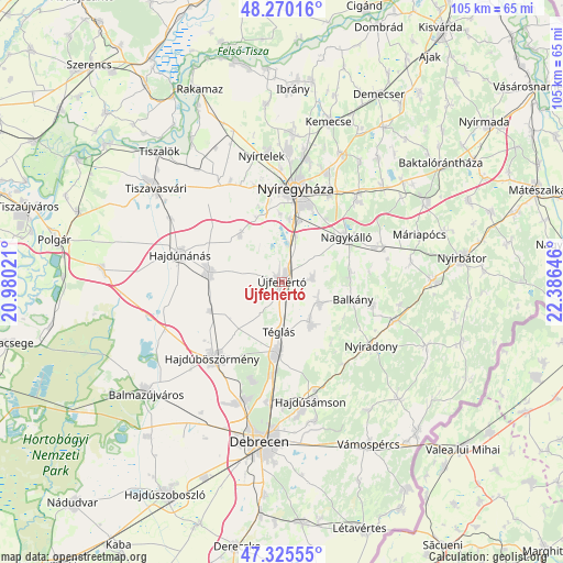
Újfehértó GPS coordinates[2]
47° 48' 0" North, 21° 40' 59.988" East
| Map corner | latitude | longitude |
|---|---|---|
| Upper-left | 48.27016°, | 20.98021° |
| Center: | 47.8°, | 21.68333° |
| Lower-right: | 47.32555°, | 22.38646° |
| Map W x H: | 105×105 km | = 65.2×65.2mi |
| max Lat: | 48.46667° ⇑22.5% North |
| Újfehértó: | 47.8° |
| min Lat: | ⇓77.5% South 45.79108° |
| min Long | Újfehértó | max Long |
| 16.27358° | 21.68333° | 22.68096° |
| W 90.3%⇐ | ⇒9.7% E |
Elevation
Elevation of Újfehértó is 121 m = 397 ft, and this is 8.7 m = 29 ft below average elevation for this country.
| Max E: |
444 m = 1457 ft | 44.7% |
| Avg. | 129.7 m = 426 ft | |
| Újfehértó | 121 m = 397 ft | |
Min E: |
71 m = 233 ft | 55.3% |
See also: Hungary elevation on elevation.city.
Geographical zone
Újfehértó is located in North temperate zone (between Tropic of Cancer and the Arctic Circle). Distance of this North polar circle is 2086.3 km =1296.4 mi to North.| Distance of | km | miles | from Újfehértó |
|---|---|---|---|
| North Pole | 4692.2 | 2915.6 | to North |
| Arctic Circle | 2086.3 | 1296.4 | to North |
| Tropic Cancer | 2708.9 | 1683.2 | to South |
| Equator | 5314.9 | 3302.5 | to South |


Nearby cities:
15 places around Újfehértó: (largest is in red/bold)
• Balkány
13.8 km =8.6 mi,  103°
103°
• Bököny
8.9 km =5.5 mi,  146°
146°
• Hajdúböszörmény
19.4 km =12.1 mi,  220°
220°
• Hajdúdorog
13.8 km =8.6 mi,  277°
277°
• Hajdúhadház
13 km =8.1 mi,  185°
185°
• Hajdúnánás
19.5 km =12.1 mi,  286°
286°
• Kállósemjén
20.3 km =12.6 mi,  70°
70°
• Kálmánháza
11.9 km =7.4 mi,  321°
321°
• Nagycserkesz
21.6 km =13.4 mi,  328°
328°
• Nagykálló
14.4 km =8.9 mi,  54°
54°
• Napkor
20.6 km =12.8 mi,  41°
41°
• Nyíradony
21 km =13 mi,  122°
122°
• Nyíregyháza
17.5 km =10.9 mi,  8°
8°
• Szakoly
17.8 km =11.1 mi, 102°
• Téglás
9.3 km =5.8 mi,  180°
180°
Sources, notices
• [Note1] Compared only with cities in Hungary existing in our database
• [Src1] Map data: © OpenStreetMap contributors (CC-BY-SA)
• [Src2] Other city data from geonames.org with taken over terms of usage.
• [Src3] Geographical zone / Annual Mean Temperature by Robert A. Rohde @ Wikipedia
