Nyíradony geodata
Nyíradony (Hajdú-Bihar) is a seat of a second-order administrative division; located in Hungary in Europe/Budapest (GMT+2) time zone. With population of 7,827 people, there are 200 cities with bigger population in this country. Compared to other cities in Hungary, 70.7% of cities are located further ↓South; 93.3% of cities are located further ←West and 77.7% of cities have lower elevation than Nyíradony. Note1


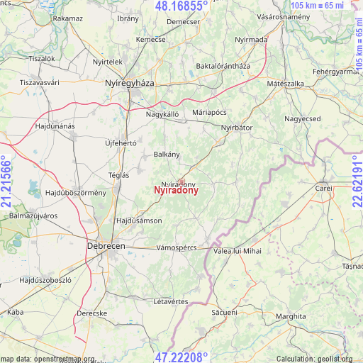
Nyíradony GPS coordinates[2]
47° 41' 50.856" North, 21° 55' 7.608" East
| Map corner | latitude | longitude |
|---|---|---|
| Upper-left | 48.16855°, | 21.21566° |
| Center: | 47.69746°, | 21.91878° |
| Lower-right: | 47.22208°, | 22.62191° |
| Map W x H: | 105.2×105.2 km | = 65.4×65.4mi |
| max Lat: | 48.46667° ⇑29.3% North |
| Nyíradony: | 47.69746° |
| min Lat: | ⇓70.7% South 45.79108° |
| min Long | Nyíradony | max Long |
| 16.27358° | 21.91878° | 22.68096° |
| W 93.3%⇐ | ⇒6.7% E |
Elevation
Elevation of Nyíradony is 152 m = 499 ft, and this is 22.3 m = 73 ft above average elevation for this country.
| Max E: |
444 m = 1457 ft | 22.3% |
| Nyíradony | 152 m 499 ft | |
| Avg. | 129.7 m = 426 ft | |
Min E: |
71 m = 233 ft | 77.7% |
See also: Hungary elevation on elevation.city.
Geographical zone
Nyíradony is located in North temperate zone (between Tropic of Cancer and the Arctic Circle). Distance of this North polar circle is 2097.7 km =1303.4 mi to North.| Distance of | km | miles | from Nyíradony |
|---|---|---|---|
| North Pole | 4703.6 | 2922.7 | to North |
| Arctic Circle | 2097.7 | 1303.4 | to North |
| Tropic Cancer | 2697.5 | 1676.1 | to South |
| Equator | 5303.5 | 3295.4 | to South |


Nearby cities:
15 places around Nyíradony: (largest is in red/bold)
• Balkány
9.1 km =5.7 mi,  332°
332°
• Bököny
13.2 km =8.2 mi,  287°
287°
• Encsencs
15.3 km =9.5 mi,  74°
74°
• Hajdúsámson
15.7 km =9.8 mi,  226°
226°
• Kisléta
17.3 km =10.7 mi,  21°
21°
• Kállósemjén
18.2 km =11.3 mi,  4°
4°
• Nyíracsád
11.2 km =7 mi,  159°
159°
• Nyírbogát
16.1 km =10 mi,  42°
42°
• Nyírbéltek
16.1 km =10 mi,  88°
88°
• Nyírlugos
9.4 km =5.8 mi, 92°
• Nyírmihálydi
5.8 km =3.6 mi, 35°
• Nyírmártonfalva
12.8 km =8 mi,  186°
186°
• Nyírábrány
17.9 km =11.1 mi,  153°
153°
• Szakoly
7.7 km =4.8 mi,  358°
358°
• Téglás
17.7 km =11 mi,  276°
276°
Sources, notices
• [Note1] Compared only with cities in Hungary existing in our database
• [Src1] Map data: © OpenStreetMap contributors (CC-BY-SA)
• [Src2] Other city data from geonames.org with taken over terms of usage.
• [Src3] Geographical zone / Annual Mean Temperature by Robert A. Rohde @ Wikipedia
