Mezőcsát geodata
Mezőcsát (Borsod-Abaúj-Zemplén) is a seat of a second-order administrative division; located in Hungary in Europe/Budapest (GMT+2) time zone. With population of 6,519 people, there are 233 cities with bigger population in this country. Compared to other cities in Hungary, 78.3% of cities are located further ↓South; 78.7% of cities are located further ←West and 84.5% of cities have higher elevation than Mezőcsát. Note1


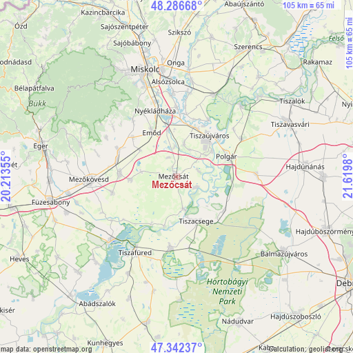
Mezőcsát GPS coordinates[2]
47° 49' 0.012" North, 20° 55' 0.012" East
| Map corner | latitude | longitude |
|---|---|---|
| Upper-left | 48.28668°, | 20.21355° |
| Center: | 47.81667°, | 20.91667° |
| Lower-right: | 47.34237°, | 21.6198° |
| Map W x H: | 105×105 km | = 65.2×65.2mi |
| max Lat: | 48.46667° ⇑21.7% North |
| Mezőcsát: | 47.81667° |
| min Lat: | ⇓78.3% South 45.79108° |
| min Long | Mezőcsát | max Long |
| 16.27358° | 20.91667° | 22.68096° |
| W 78.7%⇐ | ⇒21.3% E |
Elevation
Elevation of Mezőcsát is 91 m = 299 ft, and this is 38.7 m = 127 ft below average elevation for this country.
| Max E: |
444 m = 1457 ft | 84.5% |
| Avg. | 129.7 m = 426 ft | |
| Mezőcsát | 91 m = 299 ft | |
Min E: |
71 m = 233 ft | 15.5% |
See also: Hungary elevation on elevation.city.
Geographical zone
Mezőcsát is located in North temperate zone (between Tropic of Cancer and the Arctic Circle). Distance of this North polar circle is 2084.5 km =1295.2 mi to North.| Distance of | km | miles | from Mezőcsát |
|---|---|---|---|
| North Pole | 4690.3 | 2914.4 | to North |
| Arctic Circle | 2084.5 | 1295.2 | to North |
| Tropic Cancer | 2710.8 | 1684.4 | to South |
| Equator | 5316.7 | 3303.6 | to South |


Nearby cities:
15 places around Mezőcsát: (largest is in red/bold)
• Csincse
13.6 km =8.5 mi,  305°
305°
• Egyek
20.4 km =12.7 mi,  183°
183°
• Emőd
15 km =9.3 mi,  330°
330°
• Harsány
20.8 km =12.9 mi,  323°
323°
• Hejőbába
9.6 km =6 mi,  15°
15°
• Mezőkeresztes
16.3 km =10.1 mi,  276°
276°
• Nyékládháza
19.5 km =12.1 mi,  341°
341°
• Polgár
15.9 km =9.9 mi,  69°
69°
• Sajószöged
16.1 km =10 mi, 22°
• Sajóörös
17.2 km =10.7 mi,  30°
30°
• Szentistván
19.5 km =12.1 mi,  253°
253°
• Tiszacsege
14.4 km =8.9 mi,  154°
154°
• Tiszakeszi
7.2 km =4.5 mi,  120°
120°
• Tiszaújváros
18 km =11.2 mi,  43°
43°
• Ónod
20.4 km =12.7 mi,  0°
0°
Sources, notices
• [Note1] Compared only with cities in Hungary existing in our database
• [Src1] Map data: © OpenStreetMap contributors (CC-BY-SA)
• [Src2] Other city data from geonames.org with taken over terms of usage.
• [Src3] Geographical zone / Annual Mean Temperature by Robert A. Rohde @ Wikipedia
