Hejőbába geodata
Hejőbába (Borsod-Abaúj-Zemplén) is a populated place; located in Hungary in Europe/Budapest (GMT+2) time zone. With population of 1,949 people, there are 807 cities with bigger population in this country. Compared to other cities in Hungary, 82.4% of cities are located further ↓South; 79.4% of cities are located further ←West and 82.6% of cities have higher elevation than Hejőbába. Note1


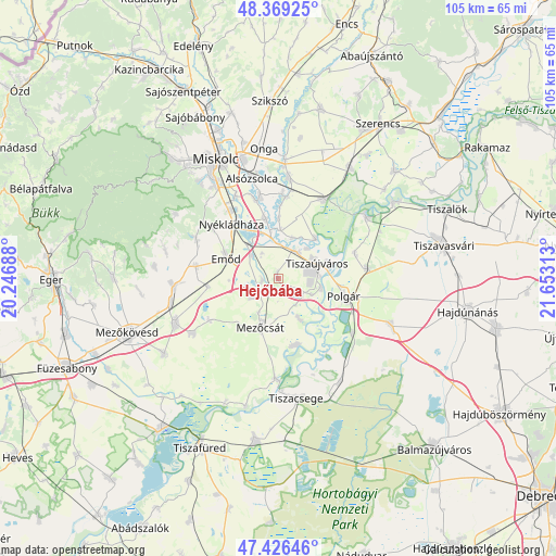
Hejőbába GPS coordinates[2]
47° 54' 0" North, 20° 57' 0" East
| Map corner | latitude | longitude |
|---|---|---|
| Upper-left | 48.36925°, | 20.24688° |
| Center: | 47.9°, | 20.95° |
| Lower-right: | 47.42646°, | 21.65313° |
| Map W x H: | 104.8×104.8 km | = 65.1×65.1mi |
| max Lat: | 48.46667° ⇑17.6% North |
| Hejőbába: | 47.9° |
| min Lat: | ⇓82.4% South 45.79108° |
| min Long | Hejőbába | max Long |
| 16.27358° | 20.95° | 22.68096° |
| W 79.4%⇐ | ⇒20.6% E |
Elevation
Elevation of Hejőbába is 93 m = 305 ft, and this is 36.7 m = 120 ft below average elevation for this country.
| Max E: |
444 m = 1457 ft | 82.6% |
| Avg. | 129.7 m = 426 ft | |
| Hejőbába | 93 m = 305 ft | |
Min E: |
71 m = 233 ft | 17.4% |
See also: Hungary elevation on elevation.city.
Geographical zone
Hejőbába is located in North temperate zone (between Tropic of Cancer and the Arctic Circle). Distance of this North polar circle is 2075.2 km =1289.5 mi to North.| Distance of | km | miles | from Hejőbába |
|---|---|---|---|
| North Pole | 4681.1 | 2908.7 | to North |
| Arctic Circle | 2075.2 | 1289.5 | to North |
| Tropic Cancer | 2720.1 | 1690.2 | to South |
| Equator | 5326 | 3309.4 | to South |


Nearby cities:
15 places around Hejőbába: (largest is in red/bold)
• Bőcs
16.7 km =10.4 mi,  4°
4°
• Csincse
13.6 km =8.5 mi,  263°
263°
• Emőd
10.6 km =6.6 mi,  290°
290°
• Harsány
16.6 km =10.3 mi,  296°
296°
• Mezőcsát
9.6 km =6 mi,  195°
195°
• Mályi
15.6 km =9.7 mi,  326°
326°
• Nyékládháza
12.7 km =7.9 mi,  316°
316°
• Polgár
13 km =8.1 mi,  106°
106°
• Sajólád
17.1 km =10.6 mi,  347°
347°
• Sajószöged
6.7 km =4.2 mi,  33°
33°
• Sajóörös
8.3 km =5.2 mi,  48°
48°
• Tiszakeszi
13.5 km =8.4 mi,  163°
163°
• Tiszalúc
17.8 km =11.1 mi, 30°
• Tiszaújváros
10.6 km =6.6 mi,  69°
69°
• Ónod
11.4 km =7.1 mi, 347°
Sources, notices
• [Note1] Compared only with cities in Hungary existing in our database
• [Src1] Map data: © OpenStreetMap contributors (CC-BY-SA)
• [Src2] Other city data from geonames.org with taken over terms of usage.
• [Src3] Geographical zone / Annual Mean Temperature by Robert A. Rohde @ Wikipedia
