Tiszakeszi geodata
Tiszakeszi (Borsod-Abaúj-Zemplén) is a populated place; located in Hungary in Europe/Budapest (GMT+2) time zone. With population of 2,692 people, there are 572 cities with bigger population in this country. Compared to other cities in Hungary, 76.2% of cities are located further ↓South; 80.2% of cities are located further ←West and 83.2% of cities have higher elevation than Tiszakeszi. Note1


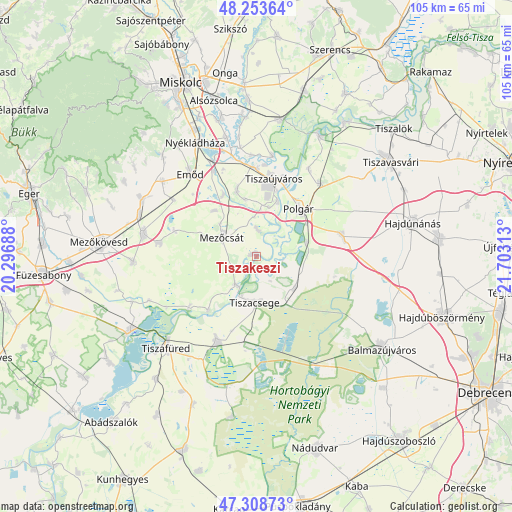
Tiszakeszi GPS coordinates[2]
47° 46' 59.988" North, 21° 0' 0" East
| Map corner | latitude | longitude |
|---|---|---|
| Upper-left | 48.25364°, | 20.29688° |
| Center: | 47.78333°, | 21° |
| Lower-right: | 47.30873°, | 21.70313° |
| Map W x H: | 105.1×105.1 km | = 65.3×65.3mi |
| max Lat: | 48.46667° ⇑23.8% North |
| Tiszakeszi: | 47.78333° |
| min Lat: | ⇓76.2% South 45.79108° |
| min Long | Tiszakeszi | max Long |
| 16.27358° | 21° | 22.68096° |
| W 80.2%⇐ | ⇒19.8% E |
Elevation
Elevation of Tiszakeszi is 92 m = 302 ft, and this is 37.7 m = 124 ft below average elevation for this country.
| Max E: |
444 m = 1457 ft | 83.2% |
| Avg. | 129.7 m = 426 ft | |
| Tiszakeszi | 92 m = 302 ft | |
Min E: |
71 m = 233 ft | 16.8% |
See also: Hungary elevation on elevation.city.
Geographical zone
Tiszakeszi is located in North temperate zone (between Tropic of Cancer and the Arctic Circle). Distance of this North polar circle is 2088.2 km =1297.5 mi to North.| Distance of | km | miles | from Tiszakeszi |
|---|---|---|---|
| North Pole | 4694.1 | 2916.8 | to North |
| Arctic Circle | 2088.2 | 1297.5 | to North |
| Tropic Cancer | 2707.1 | 1682.1 | to South |
| Equator | 5313 | 3301.3 | to South |


Nearby cities:
15 places around Tiszakeszi: (largest is in red/bold)
• Csincse
20.8 km =12.9 mi,  303°
303°
• Egyek
18.3 km =11.4 mi,  204°
204°
• Emőd
21.6 km =13.4 mi,  320°
320°
• Görbeháza
18.3 km =11.4 mi,  72°
72°
• Hejőbába
13.5 km =8.4 mi,  343°
343°
• Hortobágy
25 km =15.5 mi,  153°
153°
• Mezőcsát
7.2 km =4.5 mi, 300°
• Mezőkeresztes
23.1 km =14.4 mi,  283°
283°
• Polgár
12.7 km =7.9 mi,  43°
43°
• Sajószöged
18.5 km =11.5 mi,  0°
0°
• Sajóörös
18.7 km =11.6 mi,  7°
7°
• Szentistván
25 km =15.5 mi,  265°
265°
• Tiszacsege
9.3 km =5.8 mi,  180°
180°
• Tiszaújváros
17.8 km =11.1 mi,  20°
20°
• Ónod
24.9 km =15.5 mi,  345°
345°
Sources, notices
• [Note1] Compared only with cities in Hungary existing in our database
• [Src1] Map data: © OpenStreetMap contributors (CC-BY-SA)
• [Src2] Other city data from geonames.org with taken over terms of usage.
• [Src3] Geographical zone / Annual Mean Temperature by Robert A. Rohde @ Wikipedia
