Csenger geodata
Csenger (Szabolcs-Szatmár-Bereg) is a seat of a second-order administrative division; located in Hungary in Europe/Budapest (GMT+2) time zone. With population of 5,225 people, there are 288 cities with bigger population in this country. Compared to other cities in Hungary, 79.9% of cities are located further ↓South; 100% of cities are located further ←West and 54.3% of cities have lower elevation than Csenger. Note1


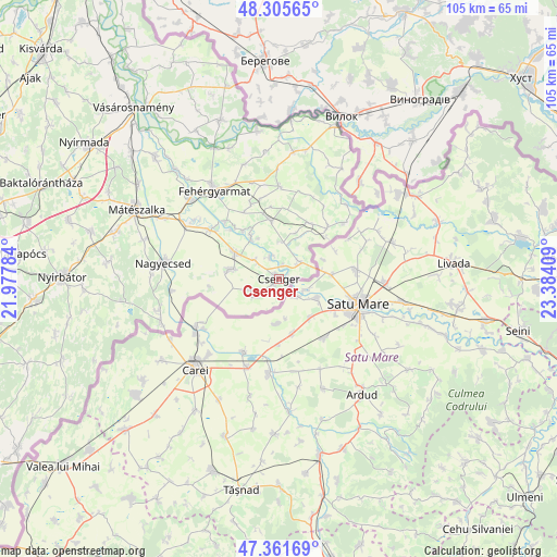
Csenger GPS coordinates[2]
47° 50' 8.952" North, 22° 40' 51.456" East
| Map corner | latitude | longitude |
|---|---|---|
| Upper-left | 48.30565°, | 21.97784° |
| Center: | 47.83582°, | 22.68096° |
| Lower-right: | 47.36169°, | 23.38409° |
| Map W x H: | 105×105 km | = 65.2×65.2mi |
| max Lat: | 48.46667° ⇑20.1% North |
| Csenger: | 47.83582° |
| min Lat: | ⇓79.9% South 45.79108° |
| min Long | Csenger | max Long |
| 16.27358° | 22.68096° | 22.68096° |
| W 100%⇐ | ⇒0% E |
Elevation
Elevation of Csenger is 120 m = 394 ft, and this is 9.7 m = 32 ft below average elevation for this country.
| Max E: |
444 m = 1457 ft | 45.7% |
| Avg. | 129.7 m = 426 ft | |
| Csenger | 120 m = 394 ft | |
Min E: |
71 m = 233 ft | 54.3% |
See also: Hungary elevation on elevation.city.
Geographical zone
Csenger is located in North temperate zone (between Tropic of Cancer and the Arctic Circle). Distance of this North polar circle is 2082.3 km =1293.9 mi to North.| Distance of | km | miles | from Csenger |
|---|---|---|---|
| North Pole | 4688.2 | 2913.1 | to North |
| Arctic Circle | 2082.3 | 1293.9 | to North |
| Tropic Cancer | 2712.9 | 1685.7 | to South |
| Equator | 5318.8 | 3304.9 | to South |


Nearby cities:
15 places around Csenger: (largest is in red/bold)
• Bátorliget
31.6 km =19.6 mi,  254°
254°
• Fehérgyarmat
20.5 km =12.7 mi,  323°
323°
• Kocsord
25 km =15.5 mi,  297°
297°
• Mátészalka
29.8 km =18.5 mi, 296°
• Mérk
23.1 km =14.4 mi,  256°
256°
• Nagyecsed
21.8 km =13.5 mi,  278°
278°
• Nyírcsaholy
26.8 km =16.7 mi,  286°
286°
• Nyírmeggyes
32.2 km =20 mi, 286°
• Porcsalma
10 km =6.2 mi, 301°
• Szamosszeg
33.1 km =20.6 mi,  314°
314°
• Tarpa
31.8 km =19.8 mi,  340°
340°
• Tunyogmatolcs
21.6 km =13.4 mi, 312°
• Tyukod
9 km =5.6 mi, 282°
• Ópályi
32 km =19.9 mi, 304°
• Ököritófülpös
15.8 km =9.8 mi, 305°
Sources, notices
• [Note1] Compared only with cities in Hungary existing in our database
• [Src1] Map data: © OpenStreetMap contributors (CC-BY-SA)
• [Src2] Other city data from geonames.org with taken over terms of usage.
• [Src3] Geographical zone / Annual Mean Temperature by Robert A. Rohde @ Wikipedia
