Tarpa geodata
Tarpa (Szabolcs-Szatmár-Bereg) is a populated place; located in Hungary in Europe/Budapest (GMT+2) time zone. With population of 2,331 people, there are 662 cities with bigger population in this country. Compared to other cities in Hungary, 91.9% of cities are located further ↓South; 99.7% of cities are located further ←West and 61.1% of cities have higher elevation than Tarpa. Note1


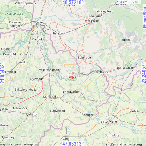
Tarpa GPS coordinates[2]
48° 6' 17.28" North, 22° 32' 14.784" East
| Map corner | latitude | longitude |
|---|---|---|
| Upper-left | 48.57218°, | 21.83432° |
| Center: | 48.1048°, | 22.53744° |
| Lower-right: | 47.63313°, | 23.24057° |
| Map W x H: | 104.4×104.4 km | = 64.9×64.9mi |
| max Lat: | 48.46667° ⇑8.1% North |
| Tarpa: | 48.1048° |
| min Lat: | ⇓91.9% South 45.79108° |
| min Long | Tarpa | max Long |
| 16.27358° | 22.53744° | 22.68096° |
| W 99.7%⇐ | ⇒0.3% E |
Elevation
Elevation of Tarpa is 109 m = 358 ft, and this is 20.7 m = 68 ft below average elevation for this country.
| Max E: |
444 m = 1457 ft | 61.1% |
| Avg. | 129.7 m = 426 ft | |
| Tarpa | 109 m = 358 ft | |
Min E: |
71 m = 233 ft | 38.9% |
See also: Hungary elevation on elevation.city.
Geographical zone
Tarpa is located in North temperate zone (between Tropic of Cancer and the Arctic Circle). Distance of this North polar circle is 2052.4 km =1275.3 mi to North.| Distance of | km | miles | from Tarpa |
|---|---|---|---|
| North Pole | 4658.3 | 2894.5 | to North |
| Arctic Circle | 2052.4 | 1275.3 | to North |
| Tropic Cancer | 2742.8 | 1704.3 | to South |
| Equator | 5348.8 | 3323.6 | to South |


Nearby cities:
15 places around Tarpa: (largest is in red/bold)
• Aranyosapáti
23.5 km =14.6 mi,  298°
298°
• Fehérgyarmat
13.6 km =8.5 mi,  186°
186°
• Kocsord
21.7 km =13.5 mi,  211°
211°
• Mátészalka
23 km =14.3 mi,  223°
223°
• Nagydobos
18.1 km =11.2 mi,  253°
253°
• Nagyecsed
28.7 km =17.8 mi,  202°
202°
• Nyírcsaholy
26.9 km =16.7 mi, 213°
• Nyírmada
25.4 km =15.8 mi,  260°
260°
• Porcsalma
24.7 km =15.3 mi,  174°
174°
• Szamosszeg
14.3 km =8.9 mi,  242°
242°
• Tunyogmatolcs
16.2 km =10.1 mi, 198°
• Tyukod
28 km =17.4 mi,  176°
176°
• Vásárosnamény
16.8 km =10.4 mi,  277°
277°
• Ópályi
19.7 km =12.2 mi,  232°
232°
• Ököritófülpös
20.8 km =12.9 mi, 186°
Sources, notices
• [Note1] Compared only with cities in Hungary existing in our database
• [Src1] Map data: © OpenStreetMap contributors (CC-BY-SA)
• [Src2] Other city data from geonames.org with taken over terms of usage.
• [Src3] Geographical zone / Annual Mean Temperature by Robert A. Rohde @ Wikipedia
