Aranyosapáti geodata
Aranyosapáti (Szabolcs-Szatmár-Bereg) is a populated place; located in Hungary in Europe/Budapest (GMT+2) time zone. With population of 2,142 people, there are 731 cities with bigger population in this country. Compared to other cities in Hungary, 96.2% of cities are located further ↓South; 98% of cities are located further ←West and 62.4% of cities have higher elevation than Aranyosapáti. Note1


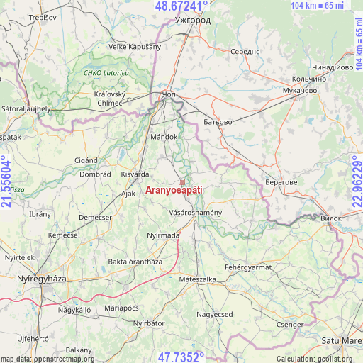
Aranyosapáti GPS coordinates[2]
48° 12' 21.42" North, 22° 15' 32.976" East
| Map corner | latitude | longitude |
|---|---|---|
| Upper-left | 48.67241°, | 21.55604° |
| Center: | 48.20595°, | 22.25916° |
| Lower-right: | 47.7352°, | 22.96229° |
| Map W x H: | 104.2×104.2 km | = 64.7×64.7mi |
| max Lat: | 48.46667° ⇑3.8% North |
| Aranyosapáti: | 48.20595° |
| min Lat: | ⇓96.2% South 45.79108° |
| min Long | Aranyosapáti | max Long |
| 16.27358° | 22.25916° | 22.68096° |
| W 98%⇐ | ⇒2% E |
Elevation
Elevation of Aranyosapáti is 108 m = 354 ft, and this is 21.7 m = 71 ft below average elevation for this country.
| Max E: |
444 m = 1457 ft | 62.4% |
| Avg. | 129.7 m = 426 ft | |
| Aranyosapáti | 108 m = 354 ft | |
Min E: |
71 m = 233 ft | 37.6% |
See also: Hungary elevation on elevation.city.
Geographical zone
Aranyosapáti is located in North temperate zone (between Tropic of Cancer and the Arctic Circle). Distance of this North polar circle is 2041.2 km =1268.3 mi to North.| Distance of | km | miles | from Aranyosapáti |
|---|---|---|---|
| North Pole | 4647.1 | 2887.6 | to North |
| Arctic Circle | 2041.2 | 1268.3 | to North |
| Tropic Cancer | 2754.1 | 1711.3 | to South |
| Equator | 5360 | 3330.5 | to South |


Nearby cities:
15 places around Aranyosapáti: (largest is in red/bold)
• Ajak
14.9 km =9.3 mi,  257°
257°
• Anarcs
11.4 km =7.1 mi,  253°
253°
• Döge
15.8 km =9.8 mi,  293°
293°
• Fényeslitke
13.8 km =8.6 mi,  301°
301°
• Gyulaháza
13.3 km =8.3 mi,  232°
232°
• Kisvárda
13.1 km =8.1 mi,  275°
275°
• Mándok
13.8 km =8.6 mi,  338°
338°
• Nagydobos
16.8 km =10.4 mi,  168°
168°
• Nyírkarász
16.9 km =10.5 mi,  222°
222°
• Nyírmada
16.1 km =10 mi,  195°
195°
• Nyírtass
19.5 km =12.1 mi,  239°
239°
• Szamosszeg
19.5 km =12.1 mi,  156°
156°
• Tornyospálca
8.8 km =5.5 mi,  320°
320°
• Tuzsér
18.6 km =11.6 mi,  325°
325°
• Vásárosnamény
9.8 km =6.1 mi, 155°
Sources, notices
• [Note1] Compared only with cities in Hungary existing in our database
• [Src1] Map data: © OpenStreetMap contributors (CC-BY-SA)
• [Src2] Other city data from geonames.org with taken over terms of usage.
• [Src3] Geographical zone / Annual Mean Temperature by Robert A. Rohde @ Wikipedia
