Vásárosnamény geodata
Vásárosnamény (Szabolcs-Szatmár-Bereg) is a seat of a second-order administrative division; located in Hungary in Europe/Budapest (GMT+2) time zone. With population of 9,310 people, there are 175 cities with bigger population in this country. Compared to other cities in Hungary, 93.1% of cities are located further ↓South; 98.4% of cities are located further ←West and 61.1% of cities have higher elevation than Vásárosnamény. Note1


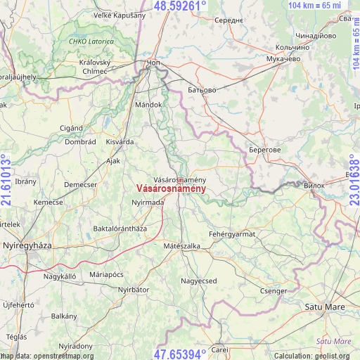
Vásárosnamény GPS coordinates[2]
48° 7' 31.512" North, 22° 18' 47.7" East
| Map corner | latitude | longitude |
|---|---|---|
| Upper-left | 48.59261°, | 21.61013° |
| Center: | 48.12542°, | 22.31325° |
| Lower-right: | 47.65394°, | 23.01638° |
| Map W x H: | 104.4×104.4 km | = 64.9×64.9mi |
| max Lat: | 48.46667° ⇑6.9% North |
| Vásárosnamény: | 48.12542° |
| min Lat: | ⇓93.1% South 45.79108° |
| min Long | Vásárosnamén | max Long |
| 16.27358° | 22.31325° | 22.68096° |
| W 98.4%⇐ | ⇒1.6% E |
Elevation
Elevation of Vásárosnamény is 109 m = 358 ft, and this is 20.7 m = 68 ft below average elevation for this country.
| Max E: |
444 m = 1457 ft | 61.1% |
| Avg. | 129.7 m = 426 ft | |
| Vásárosnamény | 109 m = 358 ft | |
Min E: |
71 m = 233 ft | 38.9% |
See also: Hungary elevation on elevation.city.
Geographical zone
Vásárosnamény is located in North temperate zone (between Tropic of Cancer and the Arctic Circle). Distance of this North polar circle is 2050.1 km =1273.9 mi to North.| Distance of | km | miles | from Vásárosnamény |
|---|---|---|---|
| North Pole | 4656 | 2893.1 | to North |
| Arctic Circle | 2050.1 | 1273.9 | to North |
| Tropic Cancer | 2745.1 | 1705.7 | to South |
| Equator | 5351 | 3325 | to South |


Nearby cities:
15 places around Vásárosnamény: (largest is in red/bold)
• Ajak
19.4 km =12.1 mi,  287°
287°
• Anarcs
16 km =9.9 mi, 290°
• Aranyosapáti
9.8 km =6.1 mi,  335°
335°
• Gyulaháza
14.6 km =9.1 mi,  273°
273°
• Kisvárda
19.8 km =12.3 mi,  300°
300°
• Mátészalka
18.9 km =11.7 mi,  177°
177°
• Nagydobos
7.6 km =4.7 mi,  185°
185°
• Nyírkarász
15.9 km =9.9 mi,  257°
257°
• Nyírmada
10.6 km =6.6 mi,  232°
232°
• Petneháza
19.1 km =11.9 mi,  247°
247°
• Szamosszeg
9.7 km =6 mi,  156°
156°
• Tarpa
16.8 km =10.4 mi,  97°
97°
• Tornyospálca
18.4 km =11.4 mi,  328°
328°
• Vaja
17.2 km =10.7 mi,  219°
219°
• Ópályi
14.2 km =8.8 mi, 176°
Sources, notices
• [Note1] Compared only with cities in Hungary existing in our database
• [Src1] Map data: © OpenStreetMap contributors (CC-BY-SA)
• [Src2] Other city data from geonames.org with taken over terms of usage.
• [Src3] Geographical zone / Annual Mean Temperature by Robert A. Rohde @ Wikipedia
