Glanggang geodata
Glanggang (East Java) is a seat of a fourth-order administrative division; located in Indonesia in Asia/Jakarta (GMT+7) time zone. In our database, there are 407 cities with bigger population. Compared to other cities in Indonesia, 64.8% of cities are located further ↑North; 56.1% of cities are located further ←West and 76.7% of cities have lower elevation than Glanggang. Note1


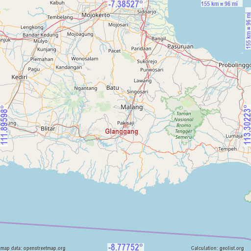
Glanggang GPS coordinates[2]
8° 4' 55.2" South, 112° 35' 56.76" East
| Map corner | latitude | longitude |
|---|---|---|
| Upper-left | -7.38527°, | 111.89598° |
| Center: | -8.082°, | 112.5991° |
| Lower-right: | -8.77752°, | 113.30223° |
| Map W x H: | 154.8×154.8 km | = 96.2×96.2mi |
| max Lat: | 5.88969° ⇑64.8% North |
| Glanggang: | -8.082° |
| min Lat: | ⇓35.2% South -10.934° |
| min Long | Glanggang | max Long |
| 95.1345° | 112.5991° | 140.9419° |
| W 56.1%⇐ | ⇒43.9% E |
Elevation
Elevation of Glanggang is 381 m = 1250 ft, and this is 151.3 m = 496 ft above average elevation for this country.
| Max E: |
3185 m = 10449 ft | 23.3% |
| Glanggang | 381 m 1250 ft | |
| Avg. | 229.7 m = 754 ft | |
Min E: |
-1 m = -3 ft | 76.7% |
See also: Indonesia elevation on elevation.city.
Geographical zone
Glanggang is located in South Torrid zone (between Equator and Tropic of Capricorn). Distance of Equator is 898.6 km =558.4 mi to North.| Distance of | km | miles | from Glanggang |
|---|---|---|---|
| Equator | 898.6 | 558.4 | to North |
| Tropic Capricorn | 1707.3 | 1060.9 | to South |
| Antarctic Circle | 6502.5 | 4040.5 | to South |
| South Pole | 9108.4 | 5659.7 | to South |


Nearby cities:
15 places around Glanggang: (largest is in red/bold)
• Bendo
1.3 km =0.8 mi,  326°
326°
• Blobo
3.7 km =2.3 mi,  183°
183°
• Boro Utara
2.4 km =1.5 mi,  154°
154°
• Golek
2.5 km =1.6 mi,  35°
35°
• Kesamben
4.1 km =2.5 mi,  299°
299°
• Kranggan
3.3 km =2.1 mi,  273°
273°
• Mboto
3.5 km =2.2 mi,  253°
253°
• Ngadilangkung
3.7 km =2.3 mi,  224°
224°
• Pakisaji
1.7 km =1.1 mi,  356°
356°
• Permanu
3 km =1.9 mi,  311°
311°
• Sidoaji
3.7 km =2.3 mi,  99°
99°
• Sukonolo Krajan
3 km =1.9 mi,  140°
140°
• Tambaksari
3.2 km =2 mi,  341°
341°
• Wadung
4.1 km =2.5 mi,  349°
349°
• Wonokerso
1.5 km =0.9 mi,  65°
65°
Sources, notices
• [Note1] Compared only with cities in Indonesia existing in our database
• [Src1] Map data: © OpenStreetMap contributors (CC-BY-SA)
• [Src2] Other city data from geonames.org with taken over terms of usage.
• [Src3] Geographical zone / Annual Mean Temperature by Robert A. Rohde @ Wikipedia
