Permanu geodata
Permanu (East Java) is a seat of a fourth-order administrative division; located in Indonesia in Asia/Jakarta (GMT+7) time zone. In our database, there are 407 cities with bigger population. Compared to other cities in Indonesia, 63.9% of cities are located further ↑North; 55.9% of cities are located further ←West and 78.2% of cities have lower elevation than Permanu. Note1


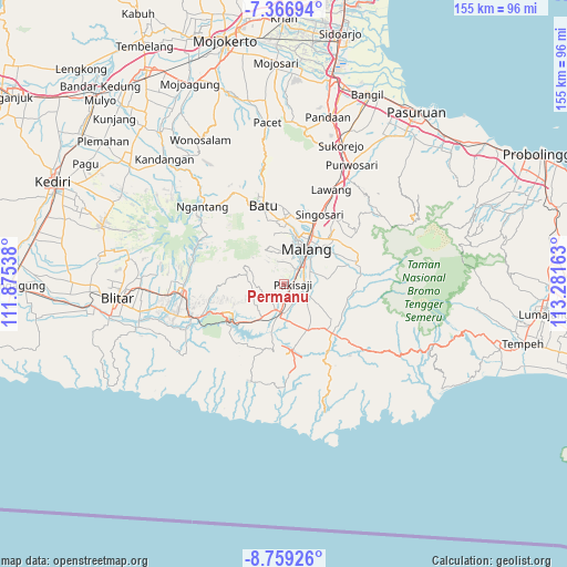
Permanu GPS coordinates[2]
8° 3' 49.32" South, 112° 34' 42.6" East
| Map corner | latitude | longitude |
|---|---|---|
| Upper-left | -7.36694°, | 111.87538° |
| Center: | -8.0637°, | 112.5785° |
| Lower-right: | -8.75926°, | 113.28163° |
| Map W x H: | 154.8×154.8 km | = 96.2×96.2mi |
| max Lat: | 5.88969° ⇑63.9% North |
| Permanu: | -8.0637° |
| min Lat: | ⇓36.1% South -10.934° |
| min Long | Permanu | max Long |
| 95.1345° | 112.5785° | 140.9419° |
| W 55.9%⇐ | ⇒44.1% E |
Elevation
Elevation of Permanu is 400 m = 1312 ft, and this is 170.3 m = 559 ft above average elevation for this country.
| Max E: |
3185 m = 10449 ft | 21.8% |
| Permanu | 400 m 1312 ft | |
| Avg. | 229.7 m = 754 ft | |
Min E: |
-1 m = -3 ft | 78.2% |
See also: Indonesia elevation on elevation.city.
Geographical zone
Permanu is located in South Torrid zone (between Equator and Tropic of Capricorn). Distance of Equator is 896.6 km =557.1 mi to North.| Distance of | km | miles | from Permanu |
|---|---|---|---|
| Equator | 896.6 | 557.1 | to North |
| Tropic Capricorn | 1709.3 | 1062.1 | to South |
| Antarctic Circle | 6504.6 | 4041.8 | to South |
| South Pole | 9110.5 | 5661 | to South |


Nearby cities:
15 places around Permanu: (largest is in red/bold)
• Bendo
1.8 km =1.1 mi,  121°
121°
• Boro Utara
5.4 km =3.4 mi,  142°
142°
• Glanggang
3 km =1.9 mi,  131°
131°
• Golek
3.7 km =2.3 mi,  90°
90°
• Kesamben
1.3 km =0.8 mi,  270°
270°
• Kranggan
2.1 km =1.3 mi,  209°
209°
• Maguan
4.6 km =2.9 mi,  259°
259°
• Mboto
3.2 km =2 mi,  199°
199°
• Ngadilangkung
4.7 km =2.9 mi,  183°
183°
• Ngasem
4.1 km =2.5 mi, 211°
• Pakisaji
2.2 km =1.4 mi,  98°
98°
• Palaan
5.7 km =3.5 mi,  216°
216°
• Tambaksari
1.6 km =1 mi,  50°
50°
• Wadung
2.5 km =1.6 mi,  36°
36°
• Wonokerso
3.9 km =2.4 mi,  111°
111°
Sources, notices
• [Note1] Compared only with cities in Indonesia existing in our database
• [Src1] Map data: © OpenStreetMap contributors (CC-BY-SA)
• [Src2] Other city data from geonames.org with taken over terms of usage.
• [Src3] Geographical zone / Annual Mean Temperature by Robert A. Rohde @ Wikipedia
