Rantepang geodata
Rantepang (South Sulawesi) is a seat of a third-order administrative division; located in Indonesia in Asia/Makassar (GMT+8) time zone. In our database, there are 407 cities with bigger population. Compared to other cities in Indonesia, 91.4% of cities are located further ↓South; 82.6% of cities are located further ←West and 95.2% of cities have lower elevation than Rantepang. Note1


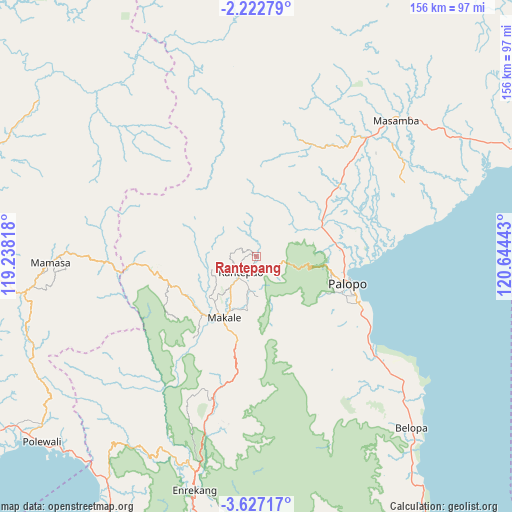
Rantepang GPS coordinates[2]
2° 55' 30.72" South, 119° 56' 28.68" East
| Map corner | latitude | longitude |
|---|---|---|
| Upper-left | -2.22279°, | 119.23818° |
| Center: | -2.9252°, | 119.9413° |
| Lower-right: | -3.62717°, | 120.64443° |
| Map W x H: | 156.2×156.2 km | = 97.1×97.1mi |
| max Lat: | 5.88969° ⇑8.6% North |
| Rantepang: | -2.9252° |
| min Lat: | ⇓91.4% South -10.934° |
| min Long | Rantepang | max Long |
| 95.1345° | 119.9413° | 140.9419° |
| W 82.6%⇐ | ⇒17.4% E |
Elevation
Elevation of Rantepang is 829 m = 2720 ft, and this is 599.3 m = 1966 ft above average elevation for this country.
| Max E: |
3185 m = 10449 ft | 4.8% |
| Rantepang | 829 m 2720 ft | |
| Avg. | 229.7 m = 754 ft | |
Min E: |
-1 m = -3 ft | 95.2% |
See also: Indonesia elevation on elevation.city.
Geographical zone
Rantepang is located in South Torrid zone (between Equator and Tropic of Capricorn). Distance of Equator is 325.3 km =202.1 mi to North.| Distance of | km | miles | from Rantepang |
|---|---|---|---|
| Equator | 325.3 | 202.1 | to North |
| Tropic Capricorn | 2280.7 | 1417.2 | to South |
| Antarctic Circle | 7075.9 | 4396.8 | to South |
| South Pole | 9681.8 | 6016 | to South |


Nearby cities:
15 places around Rantepang: (largest is in red/bold)
• Batuputih
26.9 km =16.7 mi,  97°
97°
• Belajen
46.2 km =28.7 mi,  196°
196°
• Beringinjaya
30.7 km =19.1 mi,  107°
107°
• Beuma
34.2 km =21.3 mi,  158°
158°
• Buakayu
38.9 km =24.2 mi,  218°
218°
• Getengan
29.2 km =18.1 mi,  192°
192°
• Lamasi
28.8 km =17.9 mi,  65°
65°
• Makale
21.9 km =13.6 mi,  206°
206°
• Padangsappa
52.7 km =32.7 mi,  130°
130°
• Palopo
29.4 km =18.3 mi, 104°
• Rantepao
6.9 km =4.3 mi, 224°
• Rindingallo
14.5 km =9 mi,  282°
282°
• Tangratte
24 km =14.9 mi,  234°
234°
• Totumbang
17.1 km =10.6 mi, 187°
• Walenrang
22.1 km =13.7 mi, 65°
Sources, notices
• [Note1] Compared only with cities in Indonesia existing in our database
• [Src1] Map data: © OpenStreetMap contributors (CC-BY-SA)
• [Src2] Other city data from geonames.org with taken over terms of usage.
• [Src3] Geographical zone / Annual Mean Temperature by Robert A. Rohde @ Wikipedia
