Rantepao geodata
Rantepao (South Sulawesi) is a seat of a second-order administrative division; located in Indonesia in Asia/Makassar (GMT+8) time zone. With population of 40,438 people, there are 267 cities with bigger population in this country. Compared to other cities in Indonesia, 91.3% of cities are located further ↓South; 82.5% of cities are located further ←West and 94.4% of cities have lower elevation than Rantepao. Note1


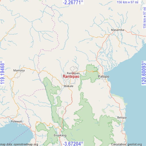
Rantepao GPS coordinates[2]
2° 58' 12.36" South, 119° 53' 52.08" East
| Map corner | latitude | longitude |
|---|---|---|
| Upper-left | -2.26771°, | 119.19468° |
| Center: | -2.9701°, | 119.8978° |
| Lower-right: | -3.67204°, | 120.60093° |
| Map W x H: | 156.1×156.2 km | = 97×97.1mi |
| max Lat: | 5.88969° ⇑8.7% North |
| Rantepao: | -2.9701° |
| min Lat: | ⇓91.3% South -10.934° |
| min Long | Rantepao | max Long |
| 95.1345° | 119.8978° | 140.9419° |
| W 82.5%⇐ | ⇒17.5% E |
Elevation
Elevation of Rantepao is 784 m = 2572 ft, and this is 554.3 m = 1819 ft above average elevation for this country.
| Max E: |
3185 m = 10449 ft | 5.6% |
| Rantepao | 784 m 2572 ft | |
| Avg. | 229.7 m = 754 ft | |
Min E: |
-1 m = -3 ft | 94.4% |
See also: Rantepao elevation on elevation.city.
Geographical zone
Rantepao is located in South Torrid zone (between Equator and Tropic of Capricorn). Distance of Equator is 330.2 km =205.2 mi to North.| Distance of | km | miles | from Rantepao |
|---|---|---|---|
| Equator | 330.2 | 205.2 | to North |
| Tropic Capricorn | 2275.7 | 1414.1 | to South |
| Antarctic Circle | 7070.9 | 4393.7 | to South |
| South Pole | 9676.8 | 6012.9 | to South |


Nearby cities:
15 places around Rantepao: (largest is in red/bold)
• Baraka
48.9 km =30.4 mi,  185°
185°
• Batuputih
31.5 km =19.6 mi,  87°
87°
• Belajen
40.1 km =24.9 mi, 191°
• Beringinjaya
34.4 km =21.4 mi,  96°
96°
• Beuma
31.9 km =19.8 mi,  147°
147°
• Buakayu
32 km =19.9 mi,  217°
217°
• Getengan
23.5 km =14.6 mi,  183°
183°
• Lamasi
35.3 km =21.9 mi,  61°
61°
• Makale
15.4 km =9.6 mi,  198°
198°
• Palopo
33.3 km =20.7 mi, 94°
• Rantepang
6.9 km =4.3 mi,  44°
44°
• Rindingallo
12.3 km =7.6 mi,  310°
310°
• Tangratte
17.3 km =10.7 mi,  239°
239°
• Totumbang
12.3 km =7.6 mi,  167°
167°
• Walenrang
28.7 km =17.8 mi, 60°
Sources, notices
• [Note1] Compared only with cities in Indonesia existing in our database
• [Src1] Map data: © OpenStreetMap contributors (CC-BY-SA)
• [Src2] Other city data from geonames.org with taken over terms of usage.
• [Src3] Geographical zone / Annual Mean Temperature by Robert A. Rohde @ Wikipedia
