Palopo geodata
Palopo (South Sulawesi) is a populated place; located in Indonesia in Asia/Makassar (GMT+8) time zone. With population of 129,273 people, there are 94 cities with bigger population in this country. Compared to other cities in Indonesia, 91.3% of cities are located further ↓South; 83.3% of cities are located further ←West and 93.7% of cities have higher elevation than Palopo. Note1


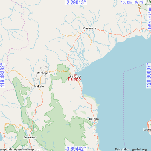
Palopo GPS coordinates[2]
2° 59' 33" South, 120° 11' 48.984" East
| Map corner | latitude | longitude |
|---|---|---|
| Upper-left | -2.29013°, | 119.49382° |
| Center: | -2.9925°, | 120.19694° |
| Lower-right: | -3.69442°, | 120.90007° |
| Map W x H: | 156.1×156.1 km | = 97×97mi |
| max Lat: | 5.88969° ⇑8.7% North |
| Palopo: | -2.9925° |
| min Lat: | ⇓91.3% South -10.934° |
| min Long | Palopo | max Long |
| 95.1345° | 120.19694° | 140.9419° |
| W 83.3%⇐ | ⇒16.7% E |
Elevation
Elevation of Palopo is 8 m = 26 ft, and this is 221.7 m = 727 ft below average elevation for this country.
| Max E: |
3185 m = 10449 ft | 93.7% |
| Avg. | 229.7 m = 754 ft | |
| Palopo | 8 m = 26 ft | |
Min E: |
-1 m = -3 ft | 6.3% |
See also: Palopo elevation on elevation.city.
Geographical zone
Palopo is located in South Torrid zone (between Equator and Tropic of Capricorn). Distance of Equator is 332.7 km =206.7 mi to North.| Distance of | km | miles | from Palopo |
|---|---|---|---|
| Equator | 332.7 | 206.7 | to North |
| Tropic Capricorn | 2273.2 | 1412.5 | to South |
| Antarctic Circle | 7068.4 | 4392.1 | to South |
| South Pole | 9674.3 | 6011.3 | to South |


Nearby cities:
15 places around Palopo: (largest is in red/bold)
• Bajo
44.8 km =27.8 mi,  163°
163°
• Batuputih
4.2 km =2.6 mi,  335°
335°
• Belopa
47.6 km =29.6 mi, 156°
• Beringinjaya
1.9 km =1.2 mi,  149°
149°
• Beuma
29.1 km =18.1 mi,  213°
213°
• Getengan
40.6 km =25.2 mi,  238°
238°
• Lamasi
19.7 km =12.2 mi,  353°
353°
• Makale
40 km =24.9 mi,  252°
252°
• Padangsappa
29.3 km =18.2 mi, 156°
• Rantepang
29.4 km =18.3 mi,  284°
284°
• Rantepao
33.3 km =20.7 mi,  274°
274°
• Rindingallo
43.8 km =27.2 mi, 283°
• Tangratte
48.5 km =30.1 mi,  262°
262°
• Totumbang
32.1 km =19.9 mi, 252°
• Walenrang
18.7 km =11.6 mi,  333°
333°
Sources, notices
• [Note1] Compared only with cities in Indonesia existing in our database
• [Src1] Map data: © OpenStreetMap contributors (CC-BY-SA)
• [Src2] Other city data from geonames.org with taken over terms of usage.
• [Src3] Geographical zone / Annual Mean Temperature by Robert A. Rohde @ Wikipedia
