Ngemplak geodata
Ngemplak (Central Java) is a populated place; located in Indonesia in Asia/Jakarta (GMT+7) time zone. With population of 23,750 people, there are 359 cities with bigger population in this country. Compared to other cities in Indonesia, 57.1% of cities are located further ↑North; 65.2% of cities are located further →East and 57.7% of cities have lower elevation than Ngemplak. Note1


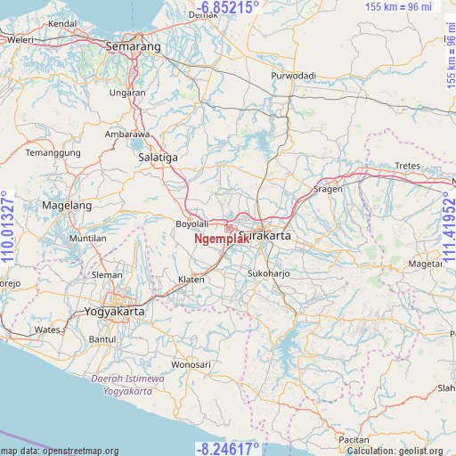
Ngemplak GPS coordinates[2]
7° 32' 58.992" South, 110° 42' 59.004" East
| Map corner | latitude | longitude |
|---|---|---|
| Upper-left | -6.85215°, | 110.01327° |
| Center: | -7.54972°, | 110.71639° |
| Lower-right: | -8.24617°, | 111.41952° |
| Map W x H: | 155×155 km | = 96.3×96.3mi |
| max Lat: | 5.88969° ⇑57.1% North |
| Ngemplak: | -7.54972° |
| min Lat: | ⇓42.9% South -10.934° |
| min Long | Ngemplak | max Long |
| 95.1345° | 110.71639° | 140.9419° |
| W 34.8%⇐ | ⇒65.2% E |
Elevation
Elevation of Ngemplak is 143 m = 469 ft, and this is 86.7 m = 284 ft below average elevation for this country.
| Max E: |
3185 m = 10449 ft | 42.3% |
| Avg. | 229.7 m = 754 ft | |
| Ngemplak | 143 m = 469 ft | |
Min E: |
-1 m = -3 ft | 57.7% |
See also: Indonesia elevation on elevation.city.
Geographical zone
Ngemplak is located in South Torrid zone (between Equator and Tropic of Capricorn). Distance of Equator is 839.5 km =521.6 mi to North.| Distance of | km | miles | from Ngemplak |
|---|---|---|---|
| Equator | 839.5 | 521.6 | to North |
| Tropic Capricorn | 1766.5 | 1097.7 | to South |
| Antarctic Circle | 6561.7 | 4077.3 | to South |
| South Pole | 9167.6 | 5696.5 | to South |


Nearby cities:
15 places around Ngemplak: (largest is in red/bold)
• Baki
10.2 km =6.3 mi,  133°
133°
• Boyolali
13.4 km =8.3 mi,  277°
277°
• Ceper
14.4 km =8.9 mi,  196°
196°
• Colomadu
4.1 km =2.5 mi,  63°
63°
• Delanggu
8.3 km =5.2 mi,  206°
206°
• Gatak
4.8 km =3 mi, 196°
• Grogol
12.6 km =7.8 mi,  116°
116°
• Jaten
20.2 km =12.6 mi,  98°
98°
• Karanganom
14.9 km =9.3 mi,  222°
222°
• Kartasura
2.4 km =1.5 mi, 95°
• Kebonarun
23.8 km =14.8 mi,  225°
225°
• Klaten
21.2 km =13.2 mi, 214°
• Sukoharjo
19.1 km =11.9 mi,  135°
135°
• Surakarta
12.7 km =7.9 mi,  93°
93°
• Trucuk
19.8 km =12.3 mi, 198°
Sources, notices
• [Note1] Compared only with cities in Indonesia existing in our database
• [Src1] Map data: © OpenStreetMap contributors (CC-BY-SA)
• [Src2] Other city data from geonames.org with taken over terms of usage.
• [Src3] Geographical zone / Annual Mean Temperature by Robert A. Rohde @ Wikipedia
