Colomadu geodata
Colomadu (Central Java) is a populated place; located in Indonesia in Asia/Jakarta (GMT+7) time zone. With population of 26,274 people, there are 345 cities with bigger population in this country. Compared to other cities in Indonesia, 56.7% of cities are located further ↑North; 65.1% of cities are located further →East and 55.6% of cities have lower elevation than Colomadu. Note1


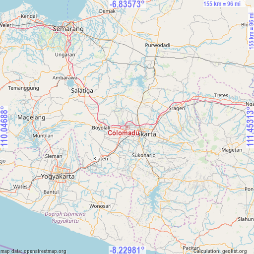
Colomadu GPS coordinates[2]
7° 31' 59.988" South, 110° 45' 0" East
| Map corner | latitude | longitude |
|---|---|---|
| Upper-left | -6.83573°, | 110.04688° |
| Center: | -7.53333°, | 110.75° |
| Lower-right: | -8.22981°, | 111.45313° |
| Map W x H: | 155×155 km | = 96.3×96.3mi |
| max Lat: | 5.88969° ⇑56.7% North |
| Colomadu: | -7.53333° |
| min Lat: | ⇓43.3% South -10.934° |
| min Long | Colomadu | max Long |
| 95.1345° | 110.75° | 140.9419° |
| W 34.9%⇐ | ⇒65.1% E |
Elevation
Elevation of Colomadu is 128 m = 420 ft, and this is 101.7 m = 334 ft below average elevation for this country.
| Max E: |
3185 m = 10449 ft | 44.4% |
| Avg. | 229.7 m = 754 ft | |
| Colomadu | 128 m = 420 ft | |
Min E: |
-1 m = -3 ft | 55.6% |
See also: Indonesia elevation on elevation.city.
Geographical zone
Colomadu is located in South Torrid zone (between Equator and Tropic of Capricorn). Distance of Equator is 837.6 km =520.5 mi to North.| Distance of | km | miles | from Colomadu |
|---|---|---|---|
| Equator | 837.6 | 520.5 | to North |
| Tropic Capricorn | 1768.3 | 1098.8 | to South |
| Antarctic Circle | 6563.5 | 4078.4 | to South |
| South Pole | 9169.4 | 5697.6 | to South |


Nearby cities:
15 places around Colomadu: (largest is in red/bold)
• Baki
9.6 km =6 mi,  157°
157°
• Boyolali
17 km =10.6 mi,  270°
270°
• Ceper
17.5 km =10.9 mi,  206°
206°
• Delanggu
11.8 km =7.3 mi,  218°
218°
• Gatak
8.1 km =5 mi, 218°
• Grogol
10.7 km =6.6 mi,  134°
134°
• Jaten
17 km =10.6 mi,  106°
106°
• Karanganom
18.8 km =11.7 mi,  226°
226°
• Karanganyar
22.6 km =14 mi, 108°
• Kartasura
2.5 km =1.6 mi, 213°
• Klaten
24.9 km =15.5 mi, 219°
• Ngemplak
4.1 km =2.5 mi,  243°
243°
• Sukoharjo
18.3 km =11.4 mi,  147°
147°
• Surakarta
9.4 km =5.8 mi, 105°
• Trucuk
22.9 km =14.2 mi, 206°
Sources, notices
• [Note1] Compared only with cities in Indonesia existing in our database
• [Src1] Map data: © OpenStreetMap contributors (CC-BY-SA)
• [Src2] Other city data from geonames.org with taken over terms of usage.
• [Src3] Geographical zone / Annual Mean Temperature by Robert A. Rohde @ Wikipedia
