Ceper geodata
Ceper (Central Java) is a populated place; located in Indonesia in Asia/Jakarta (GMT+7) time zone. With population of 28,646 people, there are 323 cities with bigger population in this country. Compared to other cities in Indonesia, 59.3% of cities are located further ↑North; 65.2% of cities are located further →East and 56% of cities have lower elevation than Ceper. Note1


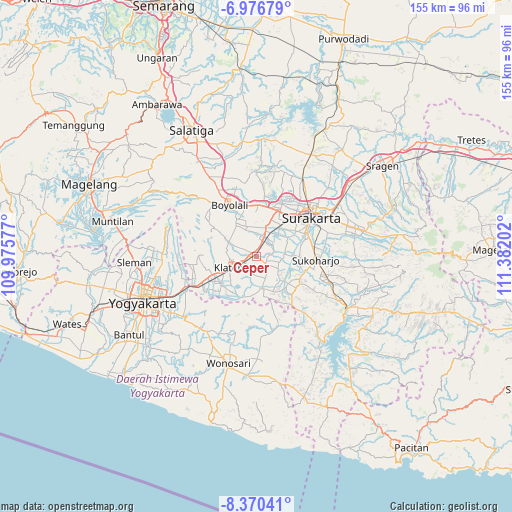
Ceper GPS coordinates[2]
7° 40' 27.012" South, 110° 40' 44.004" East
| Map corner | latitude | longitude |
|---|---|---|
| Upper-left | -6.97679°, | 109.97577° |
| Center: | -7.67417°, | 110.67889° |
| Lower-right: | -8.37041°, | 111.38202° |
| Map W x H: | 155×155 km | = 96.3×96.3mi |
| max Lat: | 5.88969° ⇑59.3% North |
| Ceper: | -7.67417° |
| min Lat: | ⇓40.7% South -10.934° |
| min Long | Ceper | max Long |
| 95.1345° | 110.67889° | 140.9419° |
| W 34.8%⇐ | ⇒65.2% E |
Elevation
Elevation of Ceper is 130 m = 427 ft, and this is 99.7 m = 327 ft below average elevation for this country.
| Max E: |
3185 m = 10449 ft | 44% |
| Avg. | 229.7 m = 754 ft | |
| Ceper | 130 m = 427 ft | |
Min E: |
-1 m = -3 ft | 56% |
See also: Indonesia elevation on elevation.city.
Geographical zone
Ceper is located in South Torrid zone (between Equator and Tropic of Capricorn). Distance of Equator is 853.3 km =530.2 mi to North.| Distance of | km | miles | from Ceper |
|---|---|---|---|
| Equator | 853.3 | 530.2 | to North |
| Tropic Capricorn | 1752.6 | 1089 | to South |
| Antarctic Circle | 6547.9 | 4068.7 | to South |
| South Pole | 9153.8 | 5687.9 | to South |


Nearby cities:
15 places around Ceper: (largest is in red/bold)
• Baki
13.4 km =8.3 mi,  59°
59°
• Boyolali
18.2 km =11.3 mi,  329°
329°
• Colomadu
17.5 km =10.9 mi,  26°
26°
• Delanggu
6.4 km =4 mi,  4°
4°
• Gatak
9.7 km =6 mi,  16°
16°
• Grogol
17.4 km =10.8 mi, 62°
• Jogonalan
16.1 km =10 mi,  258°
258°
• Karanganom
6.6 km =4.1 mi,  295°
295°
• Kartasura
15.1 km =9.4 mi, 25°
• Kebonarun
13.1 km =8.1 mi, 257°
• Klaten
8.7 km =5.4 mi,  246°
246°
• Ngemplak
14.4 km =8.9 mi, 16°
• Sukoharjo
17.5 km =10.9 mi,  89°
89°
• Trucuk
5.4 km =3.4 mi,  204°
204°
• Wedi
13.4 km =8.3 mi,  235°
235°
Sources, notices
• [Note1] Compared only with cities in Indonesia existing in our database
• [Src1] Map data: © OpenStreetMap contributors (CC-BY-SA)
• [Src2] Other city data from geonames.org with taken over terms of usage.
• [Src3] Geographical zone / Annual Mean Temperature by Robert A. Rohde @ Wikipedia
