Jaten geodata
Jaten (Central Java) is a populated place; located in Indonesia in Asia/Jakarta (GMT+7) time zone. With population of 32,378 people, there are 303 cities with bigger population in this country. Compared to other cities in Indonesia, 57.7% of cities are located further ↑North; 65.1% of cities are located further →East and 52.7% of cities have lower elevation than Jaten. Note1


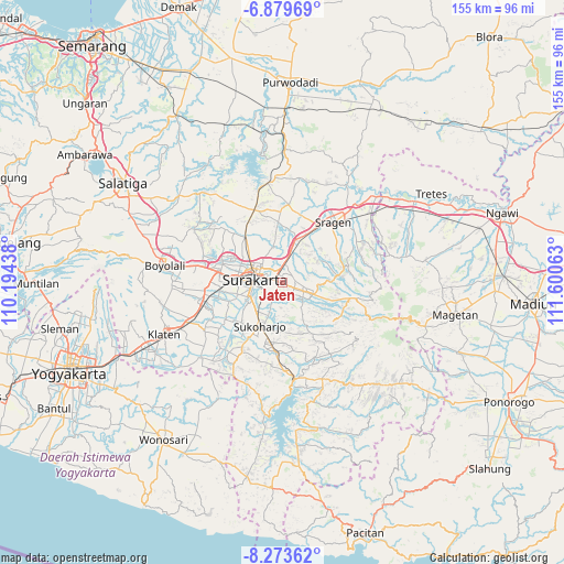
Jaten GPS coordinates[2]
7° 34' 37.992" South, 110° 53' 51" East
| Map corner | latitude | longitude |
|---|---|---|
| Upper-left | -6.87969°, | 110.19438° |
| Center: | -7.57722°, | 110.8975° |
| Lower-right: | -8.27362°, | 111.60063° |
| Map W x H: | 155×155 km | = 96.3×96.3mi |
| max Lat: | 5.88969° ⇑57.7% North |
| Jaten: | -7.57722° |
| min Lat: | ⇓42.3% South -10.934° |
| min Long | Jaten | max Long |
| 95.1345° | 110.8975° | 140.9419° |
| W 34.9%⇐ | ⇒65.1% E |
Elevation
Elevation of Jaten is 113 m = 371 ft, and this is 116.7 m = 383 ft below average elevation for this country.
| Max E: |
3185 m = 10449 ft | 47.3% |
| Avg. | 229.7 m = 754 ft | |
| Jaten | 113 m = 371 ft | |
Min E: |
-1 m = -3 ft | 52.7% |
See also: Indonesia elevation on elevation.city.
Geographical zone
Jaten is located in South Torrid zone (between Equator and Tropic of Capricorn). Distance of Equator is 842.5 km =523.5 mi to North.| Distance of | km | miles | from Jaten |
|---|---|---|---|
| Equator | 842.5 | 523.5 | to North |
| Tropic Capricorn | 1763.4 | 1095.7 | to South |
| Antarctic Circle | 6558.7 | 4075.4 | to South |
| South Pole | 9164.6 | 5694.6 | to South |


Nearby cities:
15 places around Jaten: (largest is in red/bold)
• Baki
13.1 km =8.1 mi,  252°
252°
• Ceper
26.4 km =16.4 mi, 245°
• Colomadu
17 km =10.6 mi,  286°
286°
• Delanggu
24 km =14.9 mi,  259°
259°
• Gatak
21.3 km =13.2 mi,  265°
265°
• Grogol
9.1 km =5.7 mi, 253°
• Karanganyar
5.7 km =3.5 mi,  114°
114°
• Kartasura
17.8 km =11.1 mi,  279°
279°
• Ngemplak
20.2 km =12.6 mi, 278°
• Selogiri
23.2 km =14.4 mi,  188°
188°
• Sragen
21.7 km =13.5 mi,  39°
39°
• Sukoharjo
12.5 km =7.8 mi,  211°
211°
• Surakarta
7.6 km =4.7 mi, 287°
• Trucuk
30.6 km =19 mi,  239°
239°
• Wonogiri
26.5 km =16.5 mi,  174°
174°
Sources, notices
• [Note1] Compared only with cities in Indonesia existing in our database
• [Src1] Map data: © OpenStreetMap contributors (CC-BY-SA)
• [Src2] Other city data from geonames.org with taken over terms of usage.
• [Src3] Geographical zone / Annual Mean Temperature by Robert A. Rohde @ Wikipedia
