Kebasen geodata
Kebasen (Central Java) is a seat of a fourth-order administrative division; located in Indonesia in Asia/Jakarta (GMT+7) time zone. In our database, there are 407 cities with bigger population. Compared to other cities in Indonesia, 56.7% of cities are located further ↑North; 66.3% of cities are located further →East and 78.9% of cities have higher elevation than Kebasen. Note1


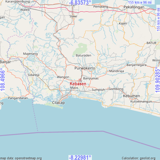
Kebasen GPS coordinates[2]
7° 31' 59.988" South, 109° 11' 58.992" East
| Map corner | latitude | longitude |
|---|---|---|
| Upper-left | -6.83573°, | 108.4966° |
| Center: | -7.53333°, | 109.19972° |
| Lower-right: | -8.22981°, | 109.90285° |
| Map W x H: | 155×155 km | = 96.3×96.3mi |
| max Lat: | 5.88969° ⇑56.7% North |
| Kebasen: | -7.53333° |
| min Lat: | ⇓43.3% South -10.934° |
| min Long | Kebasen | max Long |
| 95.1345° | 109.19972° | 140.9419° |
| W 33.7%⇐ | ⇒66.3% E |
Elevation
Elevation of Kebasen is 20 m = 66 ft, and this is 209.7 m = 688 ft below average elevation for this country.
| Max E: |
3185 m = 10449 ft | 78.9% |
| Avg. | 229.7 m = 754 ft | |
| Kebasen | 20 m = 66 ft | |
Min E: |
-1 m = -3 ft | 21.1% |
See also: Indonesia elevation on elevation.city.
Geographical zone
Kebasen is located in South Torrid zone (between Equator and Tropic of Capricorn). Distance of Equator is 837.6 km =520.5 mi to North.| Distance of | km | miles | from Kebasen |
|---|---|---|---|
| Equator | 837.6 | 520.5 | to North |
| Tropic Capricorn | 1768.3 | 1098.8 | to South |
| Antarctic Circle | 6563.5 | 4078.4 | to South |
| South Pole | 9169.4 | 5697.6 | to South |


Nearby cities:
15 places around Kebasen: (largest is in red/bold)
• Binangun
5.2 km =3.2 mi,  95°
95°
• Brak
3.6 km =2.2 mi,  142°
142°
• Brani
3.7 km =2.3 mi,  220°
220°
• Gambarsari
0.3 km =0.2 mi,  40°
40°
• Gambolempuk
5.2 km =3.2 mi, 136°
• Garbi
3.8 km =2.4 mi,  25°
25°
• Karangjati
5.9 km =3.7 mi,  154°
154°
• Karangtengah
3.8 km =2.4 mi,  197°
197°
• Losari
5.7 km =3.5 mi,  241°
241°
• Menganti
5.1 km =3.2 mi,  249°
249°
• Pesawahan
3.7 km =2.3 mi,  286°
286°
• Rawalo
2.3 km =1.4 mi,  259°
259°
• Sampang
3.4 km =2.1 mi,  185°
185°
• Sampang Selatan
3.7 km =2.3 mi,  179°
179°
• Sidasari
4.9 km =3 mi, 177°
Sources, notices
• [Note1] Compared only with cities in Indonesia existing in our database
• [Src1] Map data: © OpenStreetMap contributors (CC-BY-SA)
• [Src2] Other city data from geonames.org with taken over terms of usage.
• [Src3] Geographical zone / Annual Mean Temperature by Robert A. Rohde @ Wikipedia
