Tegalrejo geodata
Tegalrejo (East Java) is a seat of a fourth-order administrative division; located in Indonesia in Asia/Jakarta (GMT+7) time zone. In our database, there are 407 cities with bigger population. Compared to other cities in Indonesia, 67.4% of cities are located further ↑North; 50.7% of cities are located further ←West and 53.4% of cities have lower elevation than Tegalrejo. Note1


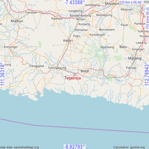
Tegalrejo GPS coordinates[2]
8° 7' 57" South, 112° 3' 58.68" East
| Map corner | latitude | longitude |
|---|---|---|
| Upper-left | -7.43586°, | 111.36318° |
| Center: | -8.1325°, | 112.0663° |
| Lower-right: | -8.82793°, | 112.76943° |
| Map W x H: | 154.8×154.8 km | = 96.2×96.2mi |
| max Lat: | 5.88969° ⇑67.4% North |
| Tegalrejo: | -8.1325° |
| min Lat: | ⇓32.6% South -10.934° |
| min Long | Tegalrejo | max Long |
| 95.1345° | 112.0663° | 140.9419° |
| W 50.7%⇐ | ⇒49.3% E |
Elevation
Elevation of Tegalrejo is 116 m = 381 ft, and this is 113.7 m = 373 ft below average elevation for this country.
| Max E: |
3185 m = 10449 ft | 46.6% |
| Avg. | 229.7 m = 754 ft | |
| Tegalrejo | 116 m = 381 ft | |
Min E: |
-1 m = -3 ft | 53.4% |
See also: Indonesia elevation on elevation.city.
Geographical zone
Tegalrejo is located in South Torrid zone (between Equator and Tropic of Capricorn). Distance of Equator is 904.2 km =561.8 mi to North.| Distance of | km | miles | from Tegalrejo |
|---|---|---|---|
| Equator | 904.2 | 561.8 | to North |
| Tropic Capricorn | 1701.7 | 1057.4 | to South |
| Antarctic Circle | 6496.9 | 4037 | to South |
| South Pole | 9102.8 | 5656.2 | to South |


Nearby cities:
15 places around Tegalrejo: (largest is in red/bold)
• Banjarsari Kidul
1.1 km =0.7 mi,  256°
256°
• Bendorubuh
7 km =4.3 mi,  265°
265°
• Blimbing
2.1 km =1.3 mi,  77°
77°
• Jatidowo
2.7 km =1.7 mi,  226°
226°
• Ngunut
6.3 km =3.9 mi,  298°
298°
• Padangan
4.2 km =2.6 mi,  275°
275°
• Pakisrejo
1.4 km =0.9 mi,  73°
73°
• Panjerrejo
5.4 km =3.4 mi, 263°
• Purwodadi
2.9 km =1.8 mi,  153°
153°
• Sukorejo
3.4 km =2.1 mi,  214°
214°
• Sumberagung
4.6 km =2.9 mi,  106°
106°
• Sumberjo
6.8 km =4.2 mi,  138°
138°
• Tenggong
5.2 km =3.2 mi,  238°
238°
• Tenggur
2.3 km =1.4 mi, 270°
• Tugu
4 km =2.5 mi, 256°
Sources, notices
• [Note1] Compared only with cities in Indonesia existing in our database
• [Src1] Map data: © OpenStreetMap contributors (CC-BY-SA)
• [Src2] Other city data from geonames.org with taken over terms of usage.
• [Src3] Geographical zone / Annual Mean Temperature by Robert A. Rohde @ Wikipedia
