Ngunut geodata
Ngunut (East Java) is a populated place; located in Indonesia in Asia/Jakarta (GMT+7) time zone. With population of 26,297 people, there are 344 cities with bigger population in this country. Compared to other cities in Indonesia, 65.9% of cities are located further ↑North; 50.2% of cities are located further ←West and 52% of cities have lower elevation than Ngunut. Note1


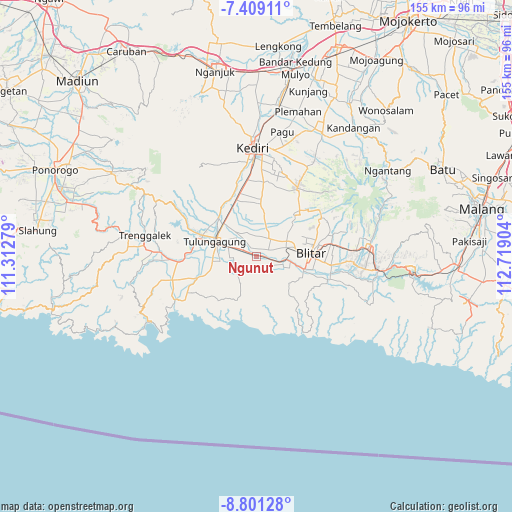
Ngunut GPS coordinates[2]
8° 6' 20.88" South, 112° 0' 57.276" East
| Map corner | latitude | longitude |
|---|---|---|
| Upper-left | -7.40911°, | 111.31279° |
| Center: | -8.1058°, | 112.01591° |
| Lower-right: | -8.80128°, | 112.71904° |
| Map W x H: | 154.8×154.8 km | = 96.2×96.2mi |
| max Lat: | 5.88969° ⇑65.9% North |
| Ngunut: | -8.1058° |
| min Lat: | ⇓34.1% South -10.934° |
| min Long | Ngunut | max Long |
| 95.1345° | 112.01591° | 140.9419° |
| W 50.2%⇐ | ⇒49.8% E |
Elevation
Elevation of Ngunut is 110 m = 361 ft, and this is 119.7 m = 393 ft below average elevation for this country.
| Max E: |
3185 m = 10449 ft | 48% |
| Avg. | 229.7 m = 754 ft | |
| Ngunut | 110 m = 361 ft | |
Min E: |
-1 m = -3 ft | 52% |
See also: Indonesia elevation on elevation.city.
Geographical zone
Ngunut is located in South Torrid zone (between Equator and Tropic of Capricorn). Distance of Equator is 901.3 km =560 mi to North.| Distance of | km | miles | from Ngunut |
|---|---|---|---|
| Equator | 901.3 | 560 | to North |
| Tropic Capricorn | 1704.6 | 1059.2 | to South |
| Antarctic Circle | 6499.9 | 4038.8 | to South |
| South Pole | 9105.8 | 5658.1 | to South |


Nearby cities:
15 places around Ngunut: (largest is in red/bold)
• Balesono
5 km =3.1 mi,  221°
221°
• Bendorubuh
3.8 km =2.4 mi,  202°
202°
• Dukuh
4.4 km =2.7 mi,  265°
265°
• Gandekan
3.2 km =2 mi,  322°
322°
• Kromasan
4.2 km =2.6 mi,  283°
283°
• Padangan
2.9 km =1.8 mi,  151°
151°
• Pandansari
4.3 km =2.7 mi,  237°
237°
• Panjerrejo
3.6 km =2.2 mi,  176°
176°
• Pulosari
3.3 km =2.1 mi,  296°
296°
• Samir
4.9 km =3 mi, 199°
• Selorejo
4.3 km =2.7 mi,  213°
213°
• Sumberingin Kulon
3.7 km =2.3 mi,  230°
230°
• Sumberjo Kulon
2.6 km =1.6 mi,  264°
264°
• Tenggur
4.4 km =2.7 mi,  131°
131°
• Tugu
4.2 km =2.6 mi,  156°
156°
Sources, notices
• [Note1] Compared only with cities in Indonesia existing in our database
• [Src1] Map data: © OpenStreetMap contributors (CC-BY-SA)
• [Src2] Other city data from geonames.org with taken over terms of usage.
• [Src3] Geographical zone / Annual Mean Temperature by Robert A. Rohde @ Wikipedia
