Leran geodata
Leran (East Java) is a seat of a fourth-order administrative division; located in Indonesia in Asia/Jakarta (GMT+7) time zone. In our database, there are 407 cities with bigger population. Compared to other cities in Indonesia, 64.4% of cities are located further ↓South; 54.1% of cities are located further →East and 60.3% of cities have higher elevation than Leran. Note1


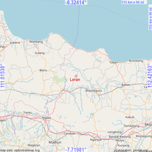
Leran GPS coordinates[2]
7° 1' 21" South, 111° 43' 6.6" East
| Map corner | latitude | longitude |
|---|---|---|
| Upper-left | -6.32414°, | 111.01538° |
| Center: | -7.0225°, | 111.7185° |
| Lower-right: | -7.71981°, | 112.42163° |
| Map W x H: | 155.2×155.2 km | = 96.4×96.4mi |
| max Lat: | 5.88969° ⇑35.6% North |
| Leran: | -7.0225° |
| min Lat: | ⇓64.4% South -10.934° |
| min Long | Leran | max Long |
| 95.1345° | 111.7185° | 140.9419° |
| W 45.9%⇐ | ⇒54.1% E |
Elevation
Elevation of Leran is 58 m = 190 ft, and this is 171.7 m = 563 ft below average elevation for this country.
| Max E: |
3185 m = 10449 ft | 60.3% |
| Avg. | 229.7 m = 754 ft | |
| Leran | 58 m = 190 ft | |
Min E: |
-1 m = -3 ft | 39.7% |
See also: Indonesia elevation on elevation.city.
Geographical zone
Leran is located in South Torrid zone (between Equator and Tropic of Capricorn). Distance of Equator is 780.8 km =485.2 mi to North.| Distance of | km | miles | from Leran |
|---|---|---|---|
| Equator | 780.8 | 485.2 | to North |
| Tropic Capricorn | 1825.1 | 1134.1 | to South |
| Antarctic Circle | 6620.3 | 4113.7 | to South |
| South Pole | 9226.2 | 5732.9 | to South |


Nearby cities:
15 places around Leran: (largest is in red/bold)
• Banaran
2.9 km =1.8 mi,  130°
130°
• Banyuurip
5.1 km =3.2 mi,  207°
207°
• Bate
4.6 km =2.9 mi,  311°
311°
• Kablukan
4.3 km =2.7 mi,  346°
346°
• Kedungharjo
5 km =3.1 mi,  5°
5°
• Krajan Weden
4.8 km =3 mi, 5°
• Medalem
2.3 km =1.4 mi, 347°
• Ngrojo
4.5 km =2.8 mi,  357°
357°
• Sarang
2.2 km =1.4 mi,  243°
243°
• Sendang
2.2 km =1.4 mi,  37°
37°
• Senori
1 km =0.6 mi, 40°
• Talok
5.1 km =3.2 mi, 350°
• Wanglu Kulon
1.5 km =0.9 mi,  77°
77°
• Wanglu Wetan
1.6 km =1 mi,  96°
96°
• Wonosari
5.6 km =3.5 mi,  187°
187°
Sources, notices
• [Note1] Compared only with cities in Indonesia existing in our database
• [Src1] Map data: © OpenStreetMap contributors (CC-BY-SA)
• [Src2] Other city data from geonames.org with taken over terms of usage.
• [Src3] Geographical zone / Annual Mean Temperature by Robert A. Rohde @ Wikipedia
