Banyuurip geodata
Banyuurip (East Java) is a seat of a fourth-order administrative division; located in Indonesia in Asia/Jakarta (GMT+7) time zone. In our database, there are 407 cities with bigger population. Compared to other cities in Indonesia, 61.8% of cities are located further ↓South; 54.6% of cities are located further →East and 67.2% of cities have lower elevation than Banyuurip. Note1


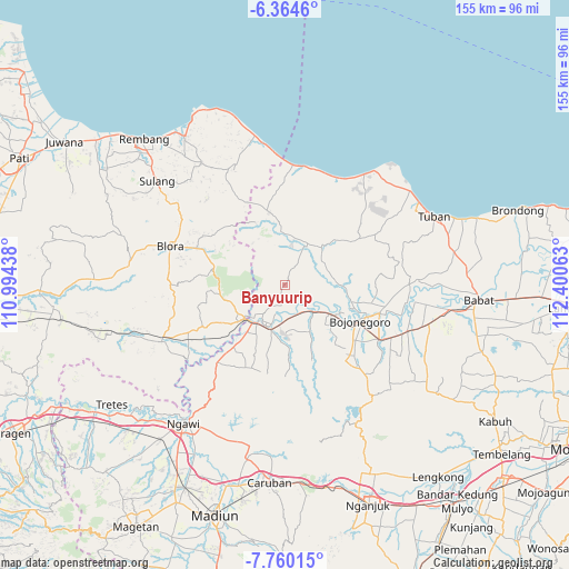
Banyuurip GPS coordinates[2]
7° 3' 46.44" South, 111° 41' 51" East
| Map corner | latitude | longitude |
|---|---|---|
| Upper-left | -6.3646°, | 110.99438° |
| Center: | -7.0629°, | 111.6975° |
| Lower-right: | -7.76015°, | 112.40063° |
| Map W x H: | 155.2×155.2 km | = 96.4×96.4mi |
| max Lat: | 5.88969° ⇑38.2% North |
| Banyuurip: | -7.0629° |
| min Lat: | ⇓61.8% South -10.934° |
| min Long | Banyuurip | max Long |
| 95.1345° | 111.6975° | 140.9419° |
| W 45.4%⇐ | ⇒54.6% E |
Elevation
Elevation of Banyuurip is 254 m = 833 ft, and this is 24.3 m = 80 ft above average elevation for this country.
| Max E: |
3185 m = 10449 ft | 32.8% |
| Banyuurip | 254 m 833 ft | |
| Avg. | 229.7 m = 754 ft | |
Min E: |
-1 m = -3 ft | 67.2% |
See also: Indonesia elevation on elevation.city.
Geographical zone
Banyuurip is located in South Torrid zone (between Equator and Tropic of Capricorn). Distance of Equator is 785.3 km =488 mi to North.| Distance of | km | miles | from Banyuurip |
|---|---|---|---|
| Equator | 785.3 | 488 | to North |
| Tropic Capricorn | 1820.6 | 1131.3 | to South |
| Antarctic Circle | 6615.9 | 4110.9 | to South |
| South Pole | 9221.7 | 5730.1 | to South |


Nearby cities:
15 places around Banyuurip: (largest is in red/bold)
• Banaran
5.2 km =3.2 mi,  59°
59°
• Karuk
6.2 km =3.9 mi,  148°
148°
• Kawengan
2.1 km =1.3 mi,  243°
243°
• Ledok
5.9 km =3.7 mi,  132°
132°
• Leran
5.1 km =3.2 mi,  27°
27°
• Malo
6.2 km =3.9 mi,  142°
142°
• Ngujung
6.9 km =4.3 mi,  169°
169°
• Sarang
3.5 km =2.2 mi,  6°
6°
• Senori
6 km =3.7 mi, 29°
• Sudah
6.9 km =4.3 mi,  156°
156°
• Tambakmerak
6.9 km =4.3 mi,  212°
212°
• Wanglu Kulon
6.1 km =3.8 mi,  37°
37°
• Wanglu Wetan
5.8 km =3.6 mi, 42°
• Wonocolo
3.3 km =2.1 mi,  294°
294°
• Wonosari
1.9 km =1.2 mi,  123°
123°
Sources, notices
• [Note1] Compared only with cities in Indonesia existing in our database
• [Src1] Map data: © OpenStreetMap contributors (CC-BY-SA)
• [Src2] Other city data from geonames.org with taken over terms of usage.
• [Src3] Geographical zone / Annual Mean Temperature by Robert A. Rohde @ Wikipedia
