Kawengan geodata
Kawengan (East Java) is a seat of a fourth-order administrative division; located in Indonesia in Asia/Jakarta (GMT+7) time zone. In our database, there are 407 cities with bigger population. Compared to other cities in Indonesia, 61.5% of cities are located further ↓South; 54.8% of cities are located further →East and 51.6% of cities have lower elevation than Kawengan. Note1


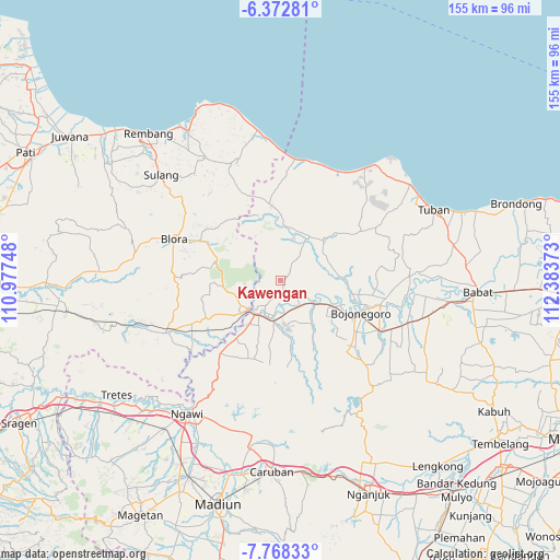
Kawengan GPS coordinates[2]
7° 4' 15.96" South, 111° 40' 50.16" East
| Map corner | latitude | longitude |
|---|---|---|
| Upper-left | -6.37281°, | 110.97748° |
| Center: | -7.0711°, | 111.6806° |
| Lower-right: | -7.76833°, | 112.38373° |
| Map W x H: | 155.2×155.2 km | = 96.4×96.4mi |
| max Lat: | 5.88969° ⇑38.5% North |
| Kawengan: | -7.0711° |
| min Lat: | ⇓61.5% South -10.934° |
| min Long | Kawengan | max Long |
| 95.1345° | 111.6806° | 140.9419° |
| W 45.2%⇐ | ⇒54.8% E |
Elevation
Elevation of Kawengan is 108 m = 354 ft, and this is 121.7 m = 399 ft below average elevation for this country.
| Max E: |
3185 m = 10449 ft | 48.4% |
| Avg. | 229.7 m = 754 ft | |
| Kawengan | 108 m = 354 ft | |
Min E: |
-1 m = -3 ft | 51.6% |
See also: Indonesia elevation on elevation.city.
Geographical zone
Kawengan is located in South Torrid zone (between Equator and Tropic of Capricorn). Distance of Equator is 786.2 km =488.5 mi to North.| Distance of | km | miles | from Kawengan |
|---|---|---|---|
| Equator | 786.2 | 488.5 | to North |
| Tropic Capricorn | 1819.7 | 1130.7 | to South |
| Antarctic Circle | 6614.9 | 4110.3 | to South |
| South Pole | 9220.8 | 5729.5 | to South |


Nearby cities:
15 places around Kawengan: (largest is in red/bold)
• Banyuurip
2.1 km =1.3 mi,  63°
63°
• Karuk
6.7 km =4.2 mi,  130°
130°
• Kedewan
6.1 km =3.8 mi,  310°
310°
• Kliteh
6.7 km =4.2 mi,  158°
158°
• Ledok
7 km =4.3 mi,  116°
116°
• Leran
6.8 km =4.2 mi,  37°
37°
• Malo
6.9 km =4.3 mi, 125°
• Ngrowo
6 km =3.7 mi,  263°
263°
• Ngujung
6.6 km =4.1 mi,  151°
151°
• Sarang
5 km =3.1 mi,  26°
26°
• Sekaran
7 km =4.3 mi,  206°
206°
• Sudah
7.1 km =4.4 mi,  139°
139°
• Tambakmerak
5.3 km =3.3 mi,  200°
200°
• Wonocolo
2.5 km =1.6 mi,  333°
333°
• Wonosari
3.4 km =2.1 mi,  92°
92°
Sources, notices
• [Note1] Compared only with cities in Indonesia existing in our database
• [Src1] Map data: © OpenStreetMap contributors (CC-BY-SA)
• [Src2] Other city data from geonames.org with taken over terms of usage.
• [Src3] Geographical zone / Annual Mean Temperature by Robert A. Rohde @ Wikipedia
