Bayad geodata
Bayad (Bali) is a seat of a fourth-order administrative division; located in Indonesia in Asia/Makassar (GMT+8) time zone. In our database, there are 407 cities with bigger population. Compared to other cities in Indonesia, 81.7% of cities are located further ↑North; 73% of cities are located further ←West and 76.4% of cities have lower elevation than Bayad. Note1


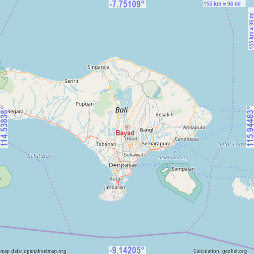
Bayad GPS coordinates[2]
8° 26' 49.92" South, 115° 14' 29.4" East
| Map corner | latitude | longitude |
|---|---|---|
| Upper-left | -7.75109°, | 114.53838° |
| Center: | -8.4472°, | 115.2415° |
| Lower-right: | -9.14205°, | 115.94463° |
| Map W x H: | 154.7×154.7 km | = 96.1×96.1mi |
| max Lat: | 5.88969° ⇑81.7% North |
| Bayad: | -8.4472° |
| min Lat: | ⇓18.3% South -10.934° |
| min Long | Bayad | max Long |
| 95.1345° | 115.2415° | 140.9419° |
| W 73%⇐ | ⇒27% E |
Elevation
Elevation of Bayad is 378 m = 1240 ft, and this is 148.3 m = 487 ft above average elevation for this country.
| Max E: |
3185 m = 10449 ft | 23.6% |
| Bayad | 378 m 1240 ft | |
| Avg. | 229.7 m = 754 ft | |
Min E: |
-1 m = -3 ft | 76.4% |
See also: Indonesia elevation on elevation.city.
Geographical zone
Bayad is located in South Torrid zone (between Equator and Tropic of Capricorn). Distance of Equator is 939.2 km =583.6 mi to North.| Distance of | km | miles | from Bayad |
|---|---|---|---|
| Equator | 939.2 | 583.6 | to North |
| Tropic Capricorn | 1666.7 | 1035.6 | to South |
| Antarctic Circle | 6461.9 | 4015.2 | to South |
| South Pole | 9067.8 | 5634.5 | to South |


Nearby cities:
15 places around Bayad: (largest is in red/bold)
• Banjar Buahan
5.9 km =3.7 mi,  354°
354°
• Banjar Bukian
5.2 km =3.2 mi,  30°
30°
• Banjar Petuludesa
5.7 km =3.5 mi,  140°
140°
• Banjar Tengah
5.3 km =3.3 mi,  94°
94°
• Banjar Triwangsakeliki
2.3 km =1.4 mi,  103°
103°
• Banjar Triwangsakelusa
2 km =1.2 mi,  68°
68°
• Brahmana
5.6 km =3.5 mi,  218°
218°
• Bunutan
2.1 km =1.3 mi,  160°
160°
• Melinggih
1.8 km =1.1 mi,  11°
11°
• Pangsan
4.3 km =2.7 mi,  327°
327°
• Pegongan
4.6 km =2.9 mi,  201°
201°
• Pemijian
2.5 km =1.6 mi,  262°
262°
• Pergan
5.6 km =3.5 mi,  294°
294°
• Tegalalang
4.3 km =2.7 mi, 74°
• Tuka
5.1 km =3.2 mi, 289°
Sources, notices
• [Note1] Compared only with cities in Indonesia existing in our database
• [Src1] Map data: © OpenStreetMap contributors (CC-BY-SA)
• [Src2] Other city data from geonames.org with taken over terms of usage.
• [Src3] Geographical zone / Annual Mean Temperature by Robert A. Rohde @ Wikipedia
