Tangkup geodata
Tangkup (East Java) is a seat of a fourth-order administrative division; located in Indonesia in Asia/Jakarta (GMT+7) time zone. In our database, there are 407 cities with bigger population. Compared to other cities in Indonesia, 61.2% of cities are located further ↑North; 69.5% of cities are located further ←West and 59.3% of cities have higher elevation than Tangkup. Note1


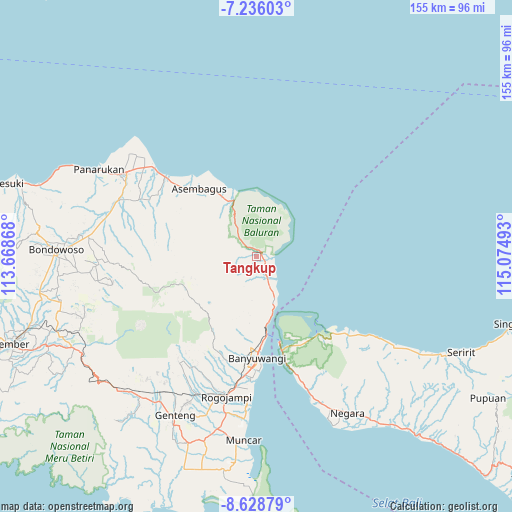
Tangkup GPS coordinates[2]
7° 55' 58.8" South, 114° 22' 18.48" East
| Map corner | latitude | longitude |
|---|---|---|
| Upper-left | -7.23603°, | 113.66868° |
| Center: | -7.933°, | 114.3718° |
| Lower-right: | -8.62879°, | 115.07493° |
| Map W x H: | 154.9×154.9 km | = 96.3×96.3mi |
| max Lat: | 5.88969° ⇑61.2% North |
| Tangkup: | -7.933° |
| min Lat: | ⇓38.8% South -10.934° |
| min Long | Tangkup | max Long |
| 95.1345° | 114.3718° | 140.9419° |
| W 69.5%⇐ | ⇒30.5% E |
Elevation
Elevation of Tangkup is 62 m = 203 ft, and this is 167.7 m = 550 ft below average elevation for this country.
| Max E: |
3185 m = 10449 ft | 59.3% |
| Avg. | 229.7 m = 754 ft | |
| Tangkup | 62 m = 203 ft | |
Min E: |
-1 m = -3 ft | 40.7% |
See also: Indonesia elevation on elevation.city.
Geographical zone
Tangkup is located in South Torrid zone (between Equator and Tropic of Capricorn). Distance of Equator is 882.1 km =548.1 mi to North.| Distance of | km | miles | from Tangkup |
|---|---|---|---|
| Equator | 882.1 | 548.1 | to North |
| Tropic Capricorn | 1723.9 | 1071.2 | to South |
| Antarctic Circle | 6519.1 | 4050.8 | to South |
| South Pole | 9125 | 5670 | to South |


Nearby cities:
15 places around Tangkup: (largest is in red/bold)
• Alasbuluh
9.4 km =5.8 mi,  155°
155°
• Awar-awar
25.1 km =15.6 mi,  319°
319°
• Bangsring
14.8 km =9.2 mi, 160°
• Bantal
22.2 km =13.8 mi, 315°
• Cungapmimbo
19.4 km =12.1 mi,  331°
331°
• Jeding
25.1 km =15.6 mi,  274°
274°
• Kalipuro
26.2 km =16.3 mi,  183°
183°
• Kedunglo
23.3 km =14.5 mi,  314°
314°
• Perante Tengah
25.6 km =15.9 mi, 319°
• Plalangan
24.4 km =15.2 mi,  250°
250°
• Possumur
13.3 km =8.3 mi, 156°
• Randuagung
23.8 km =14.8 mi, 321°
• Sempol
25.9 km =16.1 mi, 251°
• Sumberanyar
18.5 km =11.5 mi, 334°
• Wongsorejo
7.2 km =4.5 mi,  153°
153°
Sources, notices
• [Note1] Compared only with cities in Indonesia existing in our database
• [Src1] Map data: © OpenStreetMap contributors (CC-BY-SA)
• [Src2] Other city data from geonames.org with taken over terms of usage.
• [Src3] Geographical zone / Annual Mean Temperature by Robert A. Rohde @ Wikipedia
