Wongsorejo geodata
Wongsorejo (East Java) is a populated place; located in Indonesia in Asia/Jakarta (GMT+7) time zone. With population of 29,193 people, there are 320 cities with bigger population in this country. Compared to other cities in Indonesia, 61.2% of cities are located further ↑North; 69.7% of cities are located further ←West and 70.2% of cities have higher elevation than Wongsorejo. Note1


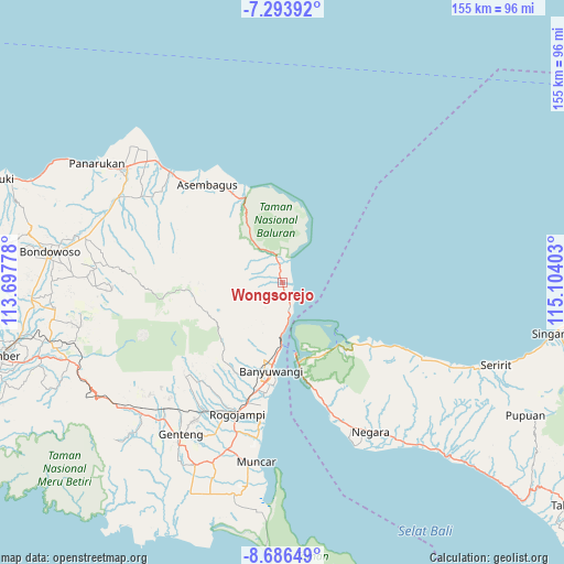
Wongsorejo GPS coordinates[2]
7° 59' 26.88" South, 114° 24' 3.24" East
| Map corner | latitude | longitude |
|---|---|---|
| Upper-left | -7.29392°, | 113.69778° |
| Center: | -7.9908°, | 114.4009° |
| Lower-right: | -8.68649°, | 115.10403° |
| Map W x H: | 154.8×154.8 km | = 96.2×96.2mi |
| max Lat: | 5.88969° ⇑61.2% North |
| Wongsorejo: | -7.9908° |
| min Lat: | ⇓38.8% South -10.934° |
| min Long | Wongsorejo | max Long |
| 95.1345° | 114.4009° | 140.9419° |
| W 69.7%⇐ | ⇒30.3% E |
Elevation
Elevation of Wongsorejo is 32 m = 105 ft, and this is 197.7 m = 649 ft below average elevation for this country.
| Max E: |
3185 m = 10449 ft | 70.2% |
| Avg. | 229.7 m = 754 ft | |
| Wongsorejo | 32 m = 105 ft | |
Min E: |
-1 m = -3 ft | 29.8% |
See also: Indonesia elevation on elevation.city.
Geographical zone
Wongsorejo is located in South Torrid zone (between Equator and Tropic of Capricorn). Distance of Equator is 888.5 km =552.1 mi to North.| Distance of | km | miles | from Wongsorejo |
|---|---|---|---|
| Equator | 888.5 | 552.1 | to North |
| Tropic Capricorn | 1717.4 | 1067.1 | to South |
| Antarctic Circle | 6512.7 | 4046.8 | to South |
| South Pole | 9118.6 | 5666 | to South |


Nearby cities:
15 places around Wongsorejo: (largest is in red/bold)
• Alasbuluh
2.2 km =1.4 mi,  162°
162°
• Bangsring
7.7 km =4.8 mi,  166°
166°
• Gilimanuk
20.4 km =12.7 mi, 169°
• Grobokan
23.9 km =14.9 mi,  185°
185°
• Kalipuro
20.3 km =12.6 mi, 193°
• Kebunjeruk
23.1 km =14.4 mi, 186°
• Klatakan
20.7 km =12.9 mi, 185°
• Krajan
21 km =13 mi,  201°
201°
• Krajan
23.7 km =14.7 mi, 191°
• Krajan
23.9 km =14.9 mi, 187°
• Krajan
24.1 km =15 mi,  212°
212°
• Krajanputuk
23.1 km =14.4 mi, 197°
• Possumur
6.1 km =3.8 mi, 160°
• Tangkup
7.2 km =4.5 mi,  333°
333°
• Tirtopuro
21.6 km =13.4 mi, 192°
Sources, notices
• [Note1] Compared only with cities in Indonesia existing in our database
• [Src1] Map data: © OpenStreetMap contributors (CC-BY-SA)
• [Src2] Other city data from geonames.org with taken over terms of usage.
• [Src3] Geographical zone / Annual Mean Temperature by Robert A. Rohde @ Wikipedia
