Alasbuluh geodata
Alasbuluh (East Java) is a seat of a fourth-order administrative division; located in Indonesia in Asia/Jakarta (GMT+7) time zone. In our database, there are 407 cities with bigger population. Compared to other cities in Indonesia, 61.7% of cities are located further ↑North; 69.7% of cities are located further ←West and 70.7% of cities have higher elevation than Alasbuluh. Note1


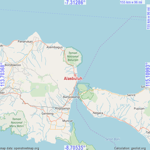
Alasbuluh GPS coordinates[2]
8° 0' 34.92" South, 114° 24' 24.48" East
| Map corner | latitude | longitude |
|---|---|---|
| Upper-left | -7.31286°, | 113.70368° |
| Center: | -8.0097°, | 114.4068° |
| Lower-right: | -8.70535°, | 115.10993° |
| Map W x H: | 154.8×154.8 km | = 96.2×96.2mi |
| max Lat: | 5.88969° ⇑61.7% North |
| Alasbuluh: | -8.0097° |
| min Lat: | ⇓38.3% South -10.934° |
| min Long | Alasbuluh | max Long |
| 95.1345° | 114.4068° | 140.9419° |
| W 69.7%⇐ | ⇒30.3% E |
Elevation
Elevation of Alasbuluh is 31 m = 102 ft, and this is 198.7 m = 652 ft below average elevation for this country.
| Max E: |
3185 m = 10449 ft | 70.7% |
| Avg. | 229.7 m = 754 ft | |
| Alasbuluh | 31 m = 102 ft | |
Min E: |
-1 m = -3 ft | 29.3% |
See also: Indonesia elevation on elevation.city.
Geographical zone
Alasbuluh is located in South Torrid zone (between Equator and Tropic of Capricorn). Distance of Equator is 890.6 km =553.4 mi to North.| Distance of | km | miles | from Alasbuluh |
|---|---|---|---|
| Equator | 890.6 | 553.4 | to North |
| Tropic Capricorn | 1715.3 | 1065.8 | to South |
| Antarctic Circle | 6510.6 | 4045.5 | to South |
| South Pole | 9116.5 | 5664.7 | to South |


Nearby cities:
15 places around Alasbuluh: (largest is in red/bold)
• Bangsring
5.5 km =3.4 mi,  168°
168°
• Gilimanuk
18.3 km =11.4 mi, 170°
• Grobokan
21.9 km =13.6 mi,  187°
187°
• Kalipuro
18.4 km =11.4 mi,  196°
196°
• Kebunjeruk
21.1 km =13.1 mi, 188°
• Klatakan
18.7 km =11.6 mi, 187°
• Krajan
19.3 km =12 mi,  205°
205°
• Krajan
21.8 km =13.5 mi, 194°
• Krajan
21.9 km =13.6 mi, 189°
• Krajanputuk
21.4 km =13.3 mi, 201°
• Possumur
3.9 km =2.4 mi,  158°
158°
• Sritanjung
22.2 km =13.8 mi, 188°
• Tangkup
9.4 km =5.8 mi,  335°
335°
• Tirtopuro
19.8 km =12.3 mi, 196°
• Wongsorejo
2.2 km =1.4 mi, 342°
Sources, notices
• [Note1] Compared only with cities in Indonesia existing in our database
• [Src1] Map data: © OpenStreetMap contributors (CC-BY-SA)
• [Src2] Other city data from geonames.org with taken over terms of usage.
• [Src3] Geographical zone / Annual Mean Temperature by Robert A. Rohde @ Wikipedia
