Selong geodata
Selong (West Nusa Tenggara) is a seat of a second-order administrative division; located in Indonesia in Asia/Makassar (GMT+8) time zone. In our database, there are 407 cities with bigger population. Compared to other cities in Indonesia, 88.2% of cities are located further ↑North; 77.8% of cities are located further ←West and 59.2% of cities have lower elevation than Selong. Note1


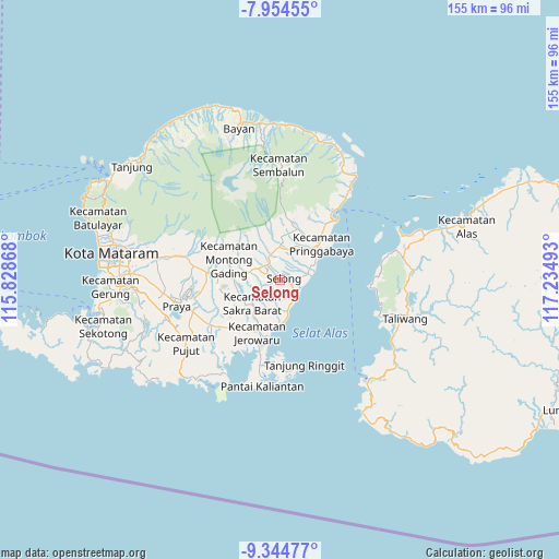
Selong GPS coordinates[2]
8° 39' 1.08" South, 116° 31' 54.48" East
| Map corner | latitude | longitude |
|---|---|---|
| Upper-left | -7.95455°, | 115.82868° |
| Center: | -8.6503°, | 116.5318° |
| Lower-right: | -9.34477°, | 117.23493° |
| Map W x H: | 154.6×154.6 km | = 96.1×96.1mi |
| max Lat: | 5.88969° ⇑88.2% North |
| Selong: | -8.6503° |
| min Lat: | ⇓11.8% South -10.934° |
| min Long | Selong | max Long |
| 95.1345° | 116.5318° | 140.9419° |
| W 77.8%⇐ | ⇒22.2% E |
Elevation
Elevation of Selong is 156 m = 512 ft, and this is 73.7 m = 242 ft below average elevation for this country.
| Max E: |
3185 m = 10449 ft | 40.8% |
| Avg. | 229.7 m = 754 ft | |
| Selong | 156 m = 512 ft | |
Min E: |
-1 m = -3 ft | 59.2% |
See also: Indonesia elevation on elevation.city.
Geographical zone
Selong is located in South Torrid zone (between Equator and Tropic of Capricorn). Distance of Equator is 961.8 km =597.6 mi to North.| Distance of | km | miles | from Selong |
|---|---|---|---|
| Equator | 961.8 | 597.6 | to North |
| Tropic Capricorn | 1644.1 | 1021.6 | to South |
| Antarctic Circle | 6439.4 | 4001.3 | to South |
| South Pole | 9045.2 | 5620.4 | to South |


Nearby cities:
15 places around Selong: (largest is in red/bold)
• Anjani Barat
5.9 km =3.7 mi,  330°
330°
• Bebae
4.9 km =3 mi,  154°
154°
• Bongkemalik
2.2 km =1.4 mi,  347°
347°
• Denggen Daya
2.9 km =1.8 mi,  233°
233°
• Gereneng
4.7 km =2.9 mi,  208°
208°
• Gubuk Timuk
3.7 km =2.3 mi,  301°
301°
• Montongtangi Timuk
5.8 km =3.6 mi, 225°
• Muhajirin
1.4 km =0.9 mi,  293°
293°
• Nyiurtebel
4 km =2.5 mi, 293°
• Pancoran
5.1 km =3.2 mi,  253°
253°
• Peresak Barat
2.4 km =1.5 mi,  110°
110°
• Rempungtimur Utara
5.6 km =3.5 mi,  319°
319°
• Setanggor
5.6 km =3.5 mi,  266°
266°
• Sukamulia
3.2 km =2 mi, 318°
• Timba Timuk
3.2 km =2 mi,  120°
120°
Sources, notices
• [Note1] Compared only with cities in Indonesia existing in our database
• [Src1] Map data: © OpenStreetMap contributors (CC-BY-SA)
• [Src2] Other city data from geonames.org with taken over terms of usage.
• [Src3] Geographical zone / Annual Mean Temperature by Robert A. Rohde @ Wikipedia
