Ganti Dua geodata
Ganti Dua (West Nusa Tenggara) is a seat of a fourth-order administrative division; located in Indonesia in Asia/Makassar (GMT+8) time zone. In our database, there are 407 cities with bigger population. Compared to other cities in Indonesia, 90.8% of cities are located further ↑North; 77% of cities are located further ←West and 53% of cities have lower elevation than Ganti Dua. Note1


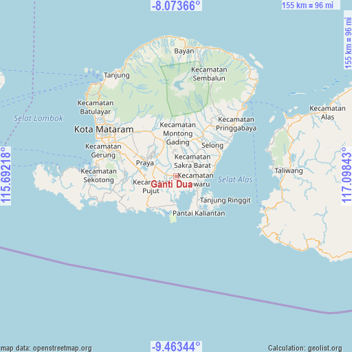
Ganti Dua GPS coordinates[2]
8° 46' 9.12" South, 116° 23' 43.08" East
| Map corner | latitude | longitude |
|---|---|---|
| Upper-left | -8.07366°, | 115.69218° |
| Center: | -8.7692°, | 116.3953° |
| Lower-right: | -9.46344°, | 117.09843° |
| Map W x H: | 154.5×154.5 km | = 96×96mi |
| max Lat: | 5.88969° ⇑90.8% North |
| Ganti Dua: | -8.7692° |
| min Lat: | ⇓9.2% South -10.934° |
| min Long | Ganti Dua | max Long |
| 95.1345° | 116.3953° | 140.9419° |
| W 77%⇐ | ⇒23% E |
Elevation
Elevation of Ganti Dua is 114 m = 374 ft, and this is 115.7 m = 380 ft below average elevation for this country.
| Max E: |
3185 m = 10449 ft | 47% |
| Avg. | 229.7 m = 754 ft | |
| Ganti Dua | 114 m = 374 ft | |
Min E: |
-1 m = -3 ft | 53% |
See also: Indonesia elevation on elevation.city.
Geographical zone
Ganti Dua is located in South Torrid zone (between Equator and Tropic of Capricorn). Distance of Equator is 975 km =605.8 mi to North.| Distance of | km | miles | from Ganti Dua |
|---|---|---|---|
| Equator | 975 | 605.8 | to North |
| Tropic Capricorn | 1630.9 | 1013.4 | to South |
| Antarctic Circle | 6426.1 | 3993 | to South |
| South Pole | 9032 | 5612.2 | to South |


Nearby cities:
15 places around Ganti Dua: (largest is in red/bold)
• Batugulung
3 km =1.9 mi,  187°
187°
• Beleka Satu
3.1 km =1.9 mi,  16°
16°
• Beraim
9.3 km =5.8 mi,  318°
318°
• Janapria
8.3 km =5.2 mi,  4°
4°
• Jembe Timur
6.3 km =3.9 mi, 16°
• Lekor Barat
6.1 km =3.8 mi,  45°
45°
• Loangmaka
6.1 km =3.8 mi,  357°
357°
• Montongtebolak
9 km =5.6 mi,  57°
57°
• Mujur
4.5 km =2.8 mi,  280°
280°
• Rangah
5.1 km =3.2 mi,  253°
253°
• Sagikmateng
6.7 km =4.2 mi,  168°
168°
• Sengkerang Tiga
2.4 km =1.5 mi,  273°
273°
• Sepit
7.8 km =4.8 mi,  67°
67°
• Sukarara Utara
8.4 km =5.2 mi,  38°
38°
• Teruwai
8 km =5 mi,  232°
232°
Sources, notices
• [Note1] Compared only with cities in Indonesia existing in our database
• [Src1] Map data: © OpenStreetMap contributors (CC-BY-SA)
• [Src2] Other city data from geonames.org with taken over terms of usage.
• [Src3] Geographical zone / Annual Mean Temperature by Robert A. Rohde @ Wikipedia
