Bengkel Utara geodata
Bengkel Utara (West Nusa Tenggara) is a seat of a fourth-order administrative division; located in Indonesia in Asia/Makassar (GMT+8) time zone. In our database, there are 407 cities with bigger population. Compared to other cities in Indonesia, 87.3% of cities are located further ↑North; 76.1% of cities are located further ←West and 65.2% of cities have higher elevation than Bengkel Utara. Note1


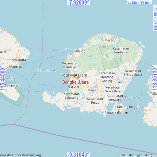
Bengkel Utara GPS coordinates[2]
8° 36' 57.24" South, 116° 8' 53.52" East
| Map corner | latitude | longitude |
|---|---|---|
| Upper-left | -7.92009°, | 115.44508° |
| Center: | -8.6159°, | 116.1482° |
| Lower-right: | -9.31043°, | 116.85133° |
| Map W x H: | 154.6×154.6 km | = 96.1×96.1mi |
| max Lat: | 5.88969° ⇑87.3% North |
| Bengkel Utara: | -8.6159° |
| min Lat: | ⇓12.7% South -10.934° |
| min Long | Bengkel Utara | max Long |
| 95.1345° | 116.1482° | 140.9419° |
| W 76.1%⇐ | ⇒23.9% E |
Elevation
Elevation of Bengkel Utara is 42 m = 138 ft, and this is 187.7 m = 616 ft below average elevation for this country.
| Max E: |
3185 m = 10449 ft | 65.2% |
| Avg. | 229.7 m = 754 ft | |
| Bengkel Utara | 42 m = 138 ft | |
Min E: |
-1 m = -3 ft | 34.8% |
See also: Indonesia elevation on elevation.city.
Geographical zone
Bengkel Utara is located in South Torrid zone (between Equator and Tropic of Capricorn). Distance of Equator is 958 km =595.3 mi to North.| Distance of | km | miles | from Bengkel Utara |
|---|---|---|---|
| Equator | 958 | 595.3 | to North |
| Tropic Capricorn | 1647.9 | 1024 | to South |
| Antarctic Circle | 6443.2 | 4003.6 | to South |
| South Pole | 9049.1 | 5622.8 | to South |


Nearby cities:
15 places around Bengkel Utara: (largest is in red/bold)
• Babakan Barat
2 km =1.2 mi,  321°
321°
• Batukuta
5.8 km =3.6 mi,  75°
75°
• Dumandesa
5.7 km =3.5 mi,  1°
1°
• Jejelok
2 km =1.2 mi, 77°
• Karang Kuripan
2.2 km =1.4 mi,  163°
163°
• Karangkebon Timur
1.7 km =1.1 mi,  223°
223°
• Karangkecicang
2.9 km =1.8 mi, 320°
• Karangparwa
2.7 km =1.7 mi,  300°
300°
• Kediri
2.1 km =1.3 mi,  169°
169°
• Lingsar
6.1 km =3.8 mi,  38°
38°
• Mataram
5 km =3.1 mi, 316°
• Sayang Lauq
5.5 km =3.4 mi,  341°
341°
• Selagalas
3.9 km =2.4 mi,  352°
352°
• Sindu
3.9 km =2.4 mi, 338°
• Tanakbeak Daye
6.1 km =3.8 mi, 80°
Sources, notices
• [Note1] Compared only with cities in Indonesia existing in our database
• [Src1] Map data: © OpenStreetMap contributors (CC-BY-SA)
• [Src2] Other city data from geonames.org with taken over terms of usage.
• [Src3] Geographical zone / Annual Mean Temperature by Robert A. Rohde @ Wikipedia
