Tanakbeak Daye geodata
Tanakbeak Daye (West Nusa Tenggara) is a seat of a fourth-order administrative division; located in Indonesia in Asia/Makassar (GMT+8) time zone. In our database, there are 407 cities with bigger population. Compared to other cities in Indonesia, 87.1% of cities are located further ↑North; 76.3% of cities are located further ←West and 55.4% of cities have lower elevation than Tanakbeak Daye. Note1


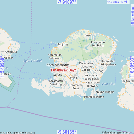
Tanakbeak Daye GPS coordinates[2]
8° 36' 24.48" South, 116° 12' 10.08" East
| Map corner | latitude | longitude |
|---|---|---|
| Upper-left | -7.91097°, | 115.49968° |
| Center: | -8.6068°, | 116.2028° |
| Lower-right: | -9.30135°, | 116.90593° |
| Map W x H: | 154.6×154.6 km | = 96.1×96.1mi |
| max Lat: | 5.88969° ⇑87.1% North |
| Tanakbeak Daye: | -8.6068° |
| min Lat: | ⇓12.9% South -10.934° |
| min Long | Tanakbeak Daye | max Long |
| 95.1345° | 116.2028° | 140.9419° |
| W 76.3%⇐ | ⇒23.7% E |
Elevation
Elevation of Tanakbeak Daye is 127 m = 417 ft, and this is 102.7 m = 337 ft below average elevation for this country.
| Max E: |
3185 m = 10449 ft | 44.6% |
| Avg. | 229.7 m = 754 ft | |
| Tanakbeak Daye | 127 m = 417 ft | |
Min E: |
-1 m = -3 ft | 55.4% |
See also: Indonesia elevation on elevation.city.
Geographical zone
Tanakbeak Daye is located in South Torrid zone (between Equator and Tropic of Capricorn). Distance of Equator is 957 km =594.7 mi to North.| Distance of | km | miles | from Tanakbeak Daye |
|---|---|---|---|
| Equator | 957 | 594.7 | to North |
| Tropic Capricorn | 1648.9 | 1024.6 | to South |
| Antarctic Circle | 6444.2 | 4004.2 | to South |
| South Pole | 9050.1 | 5623.5 | to South |


Nearby cities:
15 places around Tanakbeak Daye: (largest is in red/bold)
• Babakan Barat
7.2 km =4.5 mi,  274°
274°
• Barejulat
7.9 km =4.9 mi,  137°
137°
• Batukuta
0.6 km =0.4 mi,  322°
322°
• Bengkel Utara
6.1 km =3.8 mi,  260°
260°
• Dumandesa
7.6 km =4.7 mi,  308°
308°
• Jejelok
4.1 km =2.5 mi, 261°
• Karang Kuripan
6.2 km =3.9 mi,  239°
239°
• Karangkebon Timur
7.5 km =4.7 mi,  252°
252°
• Kediri
6.4 km =4 mi, 241°
• Lingsar
4.4 km =2.7 mi,  329°
329°
• Narmada
1.7 km =1.1 mi,  357°
357°
• Selagalas
7.1 km =4.4 mi,  293°
293°
• Selat
2.9 km =1.8 mi,  15°
15°
• Sintung Timur
2.2 km =1.4 mi,  99°
99°
• Tanaktepong
1.5 km =0.9 mi,  36°
36°
Sources, notices
• [Note1] Compared only with cities in Indonesia existing in our database
• [Src1] Map data: © OpenStreetMap contributors (CC-BY-SA)
• [Src2] Other city data from geonames.org with taken over terms of usage.
• [Src3] Geographical zone / Annual Mean Temperature by Robert A. Rohde @ Wikipedia
