Dumandesa geodata
Dumandesa (West Nusa Tenggara) is a seat of a fourth-order administrative division; located in Indonesia in Asia/Makassar (GMT+8) time zone. In our database, there are 407 cities with bigger population. Compared to other cities in Indonesia, 85.8% of cities are located further ↑North; 76.2% of cities are located further ←West and 59.1% of cities have higher elevation than Dumandesa. Note1


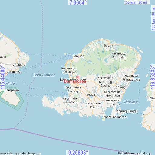
Dumandesa GPS coordinates[2]
8° 33' 51.48" South, 116° 8' 57.12" East
| Map corner | latitude | longitude |
|---|---|---|
| Upper-left | -7.8684°, | 115.44608° |
| Center: | -8.5643°, | 116.1492° |
| Lower-right: | -9.25893°, | 116.85233° |
| Map W x H: | 154.6×154.6 km | = 96.1×96.1mi |
| max Lat: | 5.88969° ⇑85.8% North |
| Dumandesa: | -8.5643° |
| min Lat: | ⇓14.2% South -10.934° |
| min Long | Dumandesa | max Long |
| 95.1345° | 116.1492° | 140.9419° |
| W 76.2%⇐ | ⇒23.8% E |
Elevation
Elevation of Dumandesa is 63 m = 207 ft, and this is 166.7 m = 547 ft below average elevation for this country.
| Max E: |
3185 m = 10449 ft | 59.1% |
| Avg. | 229.7 m = 754 ft | |
| Dumandesa | 63 m = 207 ft | |
Min E: |
-1 m = -3 ft | 40.9% |
See also: Indonesia elevation on elevation.city.
Geographical zone
Dumandesa is located in South Torrid zone (between Equator and Tropic of Capricorn). Distance of Equator is 952.3 km =591.7 mi to North.| Distance of | km | miles | from Dumandesa |
|---|---|---|---|
| Equator | 952.3 | 591.7 | to North |
| Tropic Capricorn | 1653.7 | 1027.6 | to South |
| Antarctic Circle | 6448.9 | 4007.2 | to South |
| South Pole | 9054.8 | 5626.4 | to South |


Nearby cities:
15 places around Dumandesa: (largest is in red/bold)
• Babakan Barat
4.4 km =2.7 mi,  197°
197°
• Bengkel Utara
5.7 km =3.5 mi,  181°
181°
• Dasangeria Selatan
0.9 km =0.6 mi,  351°
351°
• Jejelok
5.6 km =3.5 mi,  161°
161°
• Karangkecicang
4 km =2.5 mi,  209°
209°
• Karangparwa
5 km =3.1 mi, 209°
• Kekeri
2.5 km =1.6 mi,  289°
289°
• Lingsar
3.8 km =2.4 mi,  104°
104°
• Mambalan
2.8 km =1.7 mi,  305°
305°
• Mataram
4.2 km =2.6 mi,  239°
239°
• Narmada
6.5 km =4 mi,  117°
117°
• Penimbung Barat
2.4 km =1.5 mi,  320°
320°
• Sayang Lauq
1.9 km =1.2 mi,  252°
252°
• Selagalas
2 km =1.2 mi, 198°
• Sindu
2.6 km =1.6 mi,  216°
216°
Sources, notices
• [Note1] Compared only with cities in Indonesia existing in our database
• [Src1] Map data: © OpenStreetMap contributors (CC-BY-SA)
• [Src2] Other city data from geonames.org with taken over terms of usage.
• [Src3] Geographical zone / Annual Mean Temperature by Robert A. Rohde @ Wikipedia
