Rowotengah geodata
Rowotengah (East Java) is a seat of a fourth-order administrative division; located in Indonesia in Asia/Jakarta (GMT+7) time zone. In our database, there are 407 cities with bigger population. Compared to other cities in Indonesia, 69% of cities are located further ↑North; 61.3% of cities are located further ←West and 72.7% of cities have higher elevation than Rowotengah. Note1


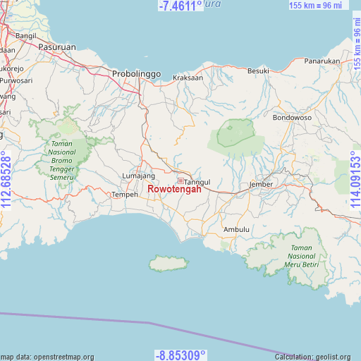
Rowotengah GPS coordinates[2]
8° 9' 27.72" South, 113° 23' 18.24" East
| Map corner | latitude | longitude |
|---|---|---|
| Upper-left | -7.4611°, | 112.68528° |
| Center: | -8.1577°, | 113.3884° |
| Lower-right: | -8.85309°, | 114.09153° |
| Map W x H: | 154.8×154.8 km | = 96.2×96.2mi |
| max Lat: | 5.88969° ⇑69% North |
| Rowotengah: | -8.1577° |
| min Lat: | ⇓31% South -10.934° |
| min Long | Rowotengah | max Long |
| 95.1345° | 113.3884° | 140.9419° |
| W 61.3%⇐ | ⇒38.7% E |
Elevation
Elevation of Rowotengah is 28 m = 92 ft, and this is 201.7 m = 662 ft below average elevation for this country.
| Max E: |
3185 m = 10449 ft | 72.7% |
| Avg. | 229.7 m = 754 ft | |
| Rowotengah | 28 m = 92 ft | |
Min E: |
-1 m = -3 ft | 27.3% |
See also: Indonesia elevation on elevation.city.
Geographical zone
Rowotengah is located in South Torrid zone (between Equator and Tropic of Capricorn). Distance of Equator is 907.1 km =563.6 mi to North.| Distance of | km | miles | from Rowotengah |
|---|---|---|---|
| Equator | 907.1 | 563.6 | to North |
| Tropic Capricorn | 1698.9 | 1055.6 | to South |
| Antarctic Circle | 6494.1 | 4035.2 | to South |
| South Pole | 9100 | 5654.5 | to South |


Nearby cities:
15 places around Rowotengah: (largest is in red/bold)
• Jatiroto
4.8 km =3 mi,  325°
325°
• Karangbayat
6.9 km =4.3 mi,  30°
30°
• Krajan Kidul Rojopolo
7.3 km =4.5 mi,  289°
289°
• Krajan Rowokangkung
7.3 km =4.5 mi,  235°
235°
• Ngampelrejo
7 km =4.3 mi,  190°
190°
• Patemon
7.2 km =4.5 mi,  84°
84°
• Pondokdalem
4.7 km =2.9 mi, 75°
• Pringgowirawan
4.7 km =2.9 mi,  35°
35°
• Rejoagung
5.8 km =3.6 mi,  147°
147°
• Rowotengu
4.3 km =2.7 mi,  107°
107°
• Semboro Lor
7.1 km =4.4 mi,  120°
120°
• Sumberbaru
4.4 km =2.7 mi,  0°
0°
• Tanggul
7.1 km =4.4 mi,  96°
96°
• Tanggul Kulon
6.6 km =4.1 mi, 96°
• Wringinagung
5.6 km =3.5 mi,  176°
176°
Sources, notices
• [Note1] Compared only with cities in Indonesia existing in our database
• [Src1] Map data: © OpenStreetMap contributors (CC-BY-SA)
• [Src2] Other city data from geonames.org with taken over terms of usage.
• [Src3] Geographical zone / Annual Mean Temperature by Robert A. Rohde @ Wikipedia
