Gesik geodata
Gesik (Central Java) is a seat of a fourth-order administrative division; located in Indonesia in Asia/Jakarta (GMT+7) time zone. In our database, there are 407 cities with bigger population. Compared to other cities in Indonesia, 62.8% of cities are located further ↓South; 61.3% of cities are located further →East and 56.3% of cities have higher elevation than Gesik. Note1


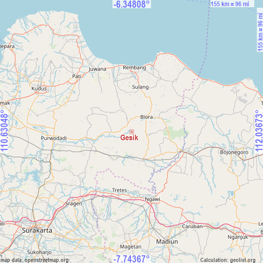
Gesik GPS coordinates[2]
7° 2' 47.04" South, 111° 20' 0.96" East
| Map corner | latitude | longitude |
|---|---|---|
| Upper-left | -6.34808°, | 110.63048° |
| Center: | -7.0464°, | 111.3336° |
| Lower-right: | -7.74367°, | 112.03673° |
| Map W x H: | 155.2×155.2 km | = 96.4×96.4mi |
| max Lat: | 5.88969° ⇑37.2% North |
| Gesik: | -7.0464° |
| min Lat: | ⇓62.8% South -10.934° |
| min Long | Gesik | max Long |
| 95.1345° | 111.3336° | 140.9419° |
| W 38.7%⇐ | ⇒61.3% E |
Elevation
Elevation of Gesik is 77 m = 253 ft, and this is 152.7 m = 501 ft below average elevation for this country.
| Max E: |
3185 m = 10449 ft | 56.3% |
| Avg. | 229.7 m = 754 ft | |
| Gesik | 77 m = 253 ft | |
Min E: |
-1 m = -3 ft | 43.7% |
See also: Indonesia elevation on elevation.city.
Geographical zone
Gesik is located in South Torrid zone (between Equator and Tropic of Capricorn). Distance of Equator is 783.5 km =486.8 mi to North.| Distance of | km | miles | from Gesik |
|---|---|---|---|
| Equator | 783.5 | 486.8 | to North |
| Tropic Capricorn | 1822.4 | 1132.4 | to South |
| Antarctic Circle | 6617.7 | 4112 | to South |
| South Pole | 9223.6 | 5731.3 | to South |


Nearby cities:
15 places around Gesik: (largest is in red/bold)
• Bacem
2.5 km =1.6 mi,  91°
91°
• Banjarejo
1.8 km =1.1 mi,  40°
40°
• Gapuk
1.5 km =0.9 mi,  359°
359°
• Gondang
4.3 km =2.7 mi,  337°
337°
• Karangtalun
3.5 km =2.2 mi,  33°
33°
• Karangtengah
2 km =1.2 mi,  291°
291°
• Kendayakan
2.7 km =1.7 mi,  254°
254°
• Ketanggi
3.9 km =2.4 mi,  330°
330°
• Mojo Wetan
4.2 km =2.6 mi,  65°
65°
• Plumbon
4.7 km =2.9 mi,  260°
260°
• Punggursugih
4.4 km =2.7 mi, 325°
• Sambirejo
0.6 km =0.4 mi,  80°
80°
• Sendanggayam
1.4 km =0.9 mi, 66°
• Talok
3.7 km =2.3 mi,  300°
300°
• Trembulrejo
4.2 km =2.6 mi,  315°
315°
Sources, notices
• [Note1] Compared only with cities in Indonesia existing in our database
• [Src1] Map data: © OpenStreetMap contributors (CC-BY-SA)
• [Src2] Other city data from geonames.org with taken over terms of usage.
• [Src3] Geographical zone / Annual Mean Temperature by Robert A. Rohde @ Wikipedia
